HOW TO
Find the raster value differences between two raster images in ArcGIS Pro
Summary
When two raster images geographically overlap, finding the difference in value between the two raster images can be useful for analysis. This article provides two workflows for ArcGIS Pro using the Raster Calculator and the Minus tools.
Procedure
Note:
The Raster Calculator and Minus tools require a Spatial Analyst license.
Use the Raster Calculator tool
- Open the ArcGIS Pro project.
- In the Geoprocessing pane, search for and click the Raster Calculator (Spatial Analyst Tools) tool. Refer to ArcGIS Pro: Run a geoprocessing tool for further instructions.
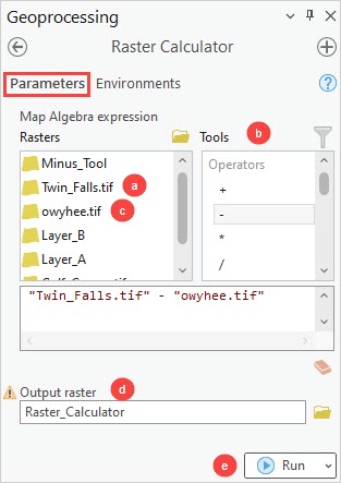
- In the Raster Calculator pane, configure the Parameters tab.
- For the Rasters parameter, double-click the first raster layer to add the layer to the expression box.
- For Tools, double-click the - operator.
- In the Rasters parameter, double-click the second raster layer to add the layer to the expression box.
- Provide a name for Output raster, and click Browse
 to specify a location for the output raster.
 - Click Run.
Use the Minus tool
- Open the ArcGIS Pro project.
- In the Geoprocessing pane, search for and click the Minus (Spatial Analyst Tools) tool. Refer to ArcGIS Pro: Run a geoprocessing tool for further instructions.
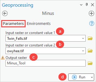
- In the Minus pane, configure the Parameters tab.
- Select the first raster layer from the Input raster or constant value 1 drop-down list.
- Select the second raster layer from the Input raster or constant value 2 drop-down list.
- Provide a name for Output raster, and click Browse
 to specify a location for the output raster.
 - Click Run.
Article ID: 000029253
Software:
- ArcGIS Pro 3 0
- ArcGIS Pro 2 8 x
- ArcGIS Pro 2 x
Get support with AI
Resolve your issue quickly with the Esri Support AI Chatbot.


Related Information
Discover more on this topic
Search for related information
Find training related to this topic
Explore ideas and give feedback
Get help from ArcGIS experts
Start chatting now