HOW TO
Fill holes in a polygon feature using geoprocessing tools in ArcGIS Pro
Summary
A polygon feature layer may contain holes to represent specific features of a given area. While the holes can be manually filled, the process can be time-consuming and complex if there are a large number of holes in a polygon. However, this process can be simplified using the geoprocessing tools in ArcGIS Pro. This article describes the options to fill holes in a polygon using the Eliminate Polygon Part tool, or the Union and Dissolve tools.
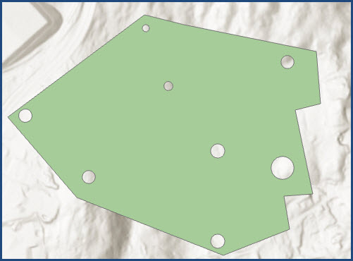
The image below shows an example of holes in a polygon.
Procedure
Use either option below to fill holes in a polygon.
Use the Eliminate Polygon Part tool
Note:
This tool requires an Advanced license level. Refer to ArcGIS Pro: ArcGIS Pro license levels for more information.
- Open the project in ArcGIS Pro.
- On the Analysis tab, in the Geoprocessing group, click Tools.
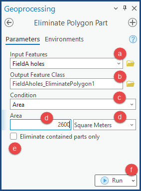
- In the Geoprocessing pane, search for and select Eliminate Polygon Part (Data Management Tools).
- In the Geoprocessing pane, under Parameters, fill in the parameters as follows:
- For Input Features, click the drop-down menu and select the polygon layer. In this example, the 'FieldA holes' polygon layer is selected.
- For Output Feature Class, the name is auto-filled. Alternatively, specify a name for the output feature class.
- For Condition, click the drop-down menu and select how the holes are to be eliminated. In this example, Area is selected.
- For Area, specify an area bigger than the area of the holes to be filled and select the unit from the drop-down list. In this example, Square Meters is selected. Refer to How To: Calculate the area of holes in a polygon feature in ArcGIS Pro to calculate the area of the holes.
- Uncheck the Eliminate contained parts only check box.
- Click Run to run the tool.
Use the Union and Dissolve tools
In ArcGIS Pro, use the Union tool to create a feature from the holes in the polygon feature layer and the Dissolve tool to aggregate the features created with the polygon.
- On the Analysis tab, in the Geoprocessing group, click Tools.
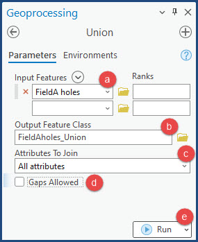
- In the Geoprocessing pane, search for and select Union (Data Management Tools).
- In the Geoprocessing pane, under Parameters, fill in the parameters as follows:
- For Input Features, click the drop-down menu and select the polygon layer. In this example, the 'FieldA holes' polygon layer is selected.
- For Output Feature Class, the name is auto-filled. Alternatively, specify a name for the output feature class.
- For Attributes To Join, click the drop-down menu and select All attributes.
- Uncheck the Gaps Allowed check box. This allows the tool to create a feature for the areas completely enclosed by the polygon.
- Click Run to run the tool.
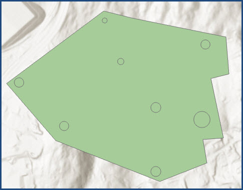
The image below shows the feature created to fill the holes.
- On the Analysis tab, in the Geoprocessing group, click Tools.
- In the Geoprocessing pane, search for and select Dissolve (Data Management Tools).
- In the Geoprocessing pane, under Parameters, fill in the parameters as follows:
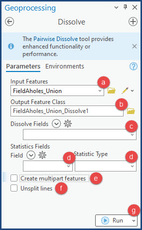
- For Input Features, click the drop-down menu and select the output layer of the Union tool from Step 3. In this example, the 'FieldAholes_Union' polygon layer is selected.
- For Output Feature Class, the name is auto-filled. Alternatively, specify a name for the output feature class.
- For Dissolve Fields, click the drop-down menu and select the field if necessary. In this example, no field is selected.
- For Statistics Fields, click the drop-down menus and select the field for Field and the statistic type under Statistic Type if necessary. In this example, the field and statistic type are not specified.
- Uncheck the Create multipart features check box.
- Uncheck the Unsplit lines check box.
- Click Run to run the tool.
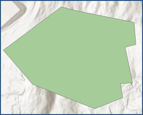
The image below shows the holes in the polygon are filled.
Article ID: 000030533
- ArcGIS Pro 3 1
- ArcGIS Pro 3 0
- ArcGIS Pro 2 9x
Get support with AI
Resolve your issue quickly with the Esri Support AI Chatbot.


Related Information
Discover more on this topic
Search for related information
Find training related to this topic
Explore ideas and give feedback
Get help from ArcGIS experts
Start chatting now