HOW TO
Display the sum of intersecting features in Portal for ArcGIS Map Viewer pop-ups
Summary
In Portal for ArcGIS Map Viewer Classic, Arcade expressions can be used to format the text displayed in a pop-up according to the specifications applied. This article provides an example and instructions using the Arcade expressions to display the sum of intersecting features for pop-ups in Portal for ArcGIS Map Viewer Classic.
Procedure
The workflow provided utilizes the Arcade functions listed in the table below to display the sum of point features within the polygon features in Portal for ArcGIS Map Viewer pop-ups.
| Arcade Function | Attribute Result |
|---|---|
| Count(features) | Returns the number of features in a layer. |
| Intersects(features, inputGeometry) | Returns features from a FeatureSet that intersects another geometry. |
| FeatureSetByName(featureSetCollection, title) | Creates a FeatureSet from a Feature Layer based on its name within a map or feature service. |
| Round(value, numberOfDecimalPlaces) | Returns the input value, rounded to the given number of decimal places. |
| AreaGeodetic(features, unitOfMeasurement) | Returns the geodetic area of the feature in the given units. |
| Filter(features, sqlExpression) | Filters features using an SQL92 expression. |
| Text(value, 'format') | Converts the argument into a string and optionally formats it. |
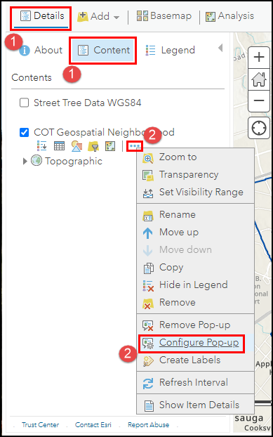
- In Map Viewer Classic, click Details, and click Content.
- Click More Options
 next to the polygon layer, and click Configure Pop-up.
- Scroll down to the Attribute Expressions section in the Configure Pop-up pane and click ADD.
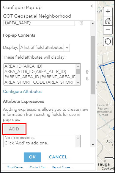
- In the Expression window, specify a name for the new expression as required.
- In the Expression dialog box, insert the following Arcade expression:
- Get all the trees and count them.
var <variableName> = Count(Intersects(FeatureSetByName($map, "<layerName>"), $feature))
- Calculate the tree density.
var <variableName1> = Round(TreesCount / AreaGeodetic($feature, '<unitOfMeasurement>'), <numberOfDecimalPlaces>)
- Get all the maple trees and count them.
var <variableName2> = Count(Intersects(Filter(FeatureSetByName($map, "<layerName>"), "<fieldName> LIKE '%<fieldValue>%'"), $feature))
- Construct the pop-up string.
var <variableName3> = "<text> " + $feature["fieldName1"] + " <text1> " + Text(<variableName>, '<format>') + " <text2> " + Text(<variableName1>, '<format>') + " <text3> " + Text(<variableName2>, '<format>') + " <text4>"

return <variableName3>
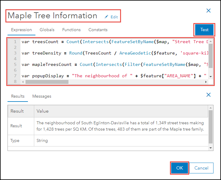
The following code block demonstrates the full working Arcade expressions.
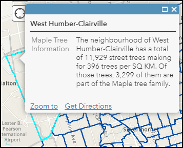
var treesCount = Count(Intersects(FeatureSetByName($map, "Street Tree Data WGS84"), $feature))

var treeDensity = Round(TreesCount / AreaGeodetic($feature, 'square-kilometers'), 0)

var mapleTreesCount = Count(Intersects(Filter(FeatureSetByName($map, "Street Tree Data WGS84"), "COMMON_NAM LIKE '%MAPLE%'"), $feature))

var popupDisplay = "The neighbourhood of " + $feature["AREA_NAME"] + " has a total of " + Text(treesCount, '#,###') + " street trees making for " + Text(treeDensity, '#,###') + " trees per SQ KM. Of those trees, " + Text(mapleTreesCount, '#,###') + " of them are part of the Maple tree family."

return popupDisplay
- Click Test to view a preview of the expression result. If the required result is achieved, click OK.
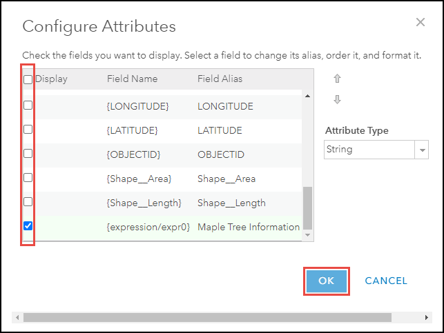
- Under the Pop-up Contents section in the Configure Pop-up pane, click Configure Attributes.
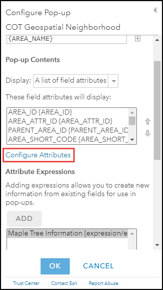
- In the Configure Attributes window, check the fields required to be displayed in the pop-up and click OK. In this example, the Maple Tree Information field is checked, while all other fields are unchecked.
- Click OK at the bottom of the Configure Pop-up pane.
The image below shows the configured pop-up with the information on the total number of trees, and the number of Maple trees for each polygon feature displayed.
Article ID: 000028155
- ArcGIS Online
- Portal for ArcGIS
Get support with AI
Resolve your issue quickly with the Esri Support AI Chatbot.


Related Information
Discover more on this topic
Search for related information
Find training related to this topic
Explore ideas and give feedback
Get help from ArcGIS experts
Start chatting now