HOW TO
Create a locator map to display all extents in a map series in ArcGIS Pro
Summary
In ArcGIS Pro, a layout can include a map series, highlight specific areas of interest, and feature a locator map. The locator map provides an overview of the extent of each feature within the map series and illustrates the relationship between each page and the broader geographic area.
This article describes the workflow to create a locator map to display the extents of each page in a map series in ArcGIS Pro.
Procedure
- In ArcGIS Pro, create a locator map.
- In the Catalog pane, duplicate the active map to create a locator map. Right-click the locator map and select Open.
- Rename the locator map. In this example, the active map is named Venice Landmarks and the locator map is named Venice Overview.
- On the locator map view tab, in the Contents pane, uncheck the check boxes for the feature layers to display only the map.
- Create a map series.
- Create a layout and insert two map frames; the active map and the locator map views. Refer to ArcGIS Pro: Insert a map frame for further instructions.
- In the layout view, create a map series for the active map.
- On the ribbon, on the Layout tab, in the Map group, click Activate
 . Pan and zoom the map to adjust the extent.
 - On the Layout tab, in the Map group, click Close Activation
 .
. - Select the locator map frame. Repeat Steps 2(c) through 2(d) to adjust the map extent.
- Select the locator map frame and insert an extent indicator. Optionally, change the extent indicator's symbol. In this example, the extent indicator is blue in color.
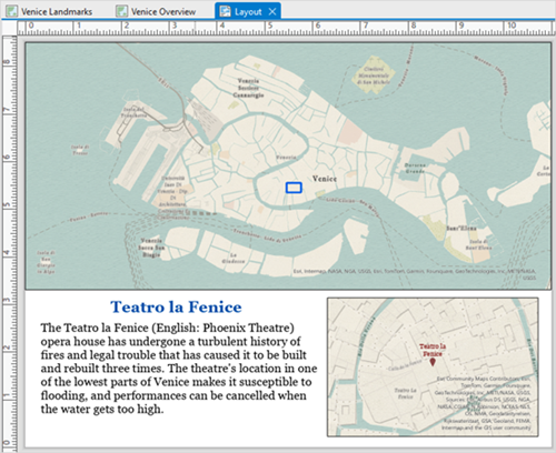
The image below is an example of a map series with two map frames: the locator map (above) and the active map (below).
- Create a polygon feature class and draw extent indicators by tracing the outline of the map frame.
- On the active map view tab, create a polygon feature class. Refer to Steps 1 through 3 in ArcGIS Pro: Create a stand-alone feature class for instructions.
- In the Create Feature Class wizard, click Finish. The polygon feature class is added to the Contents pane.
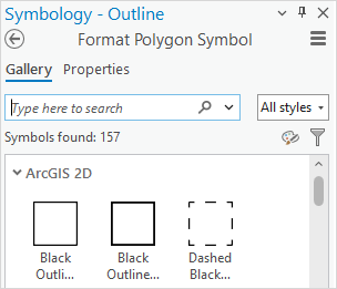
- In the Symbology pane, on the Gallery tab, change the symbology of the polygon feature class to an outline symbol.
- In the layout view, select the active map frame. On the ribbon, on the Layout tab, in the Map group, click Activate
 .
. - On the ribbon, click the Edit tab. In the Features group, click Create.
- In the Create Features pane, select the polygon feature class and click the Polygon
 tool.
tool. - Draw a rectangle to trace the outline of the active map frame.
- Click Finish
 or press F2 to create the outline. On the ribbon, click Save.
 - On the Layout tab, in the Map group, click Close Activation
 .
. - In the Contents pane, on the List Map Series Pages button, navigate the map series pages and repeat Steps 3(d) through 3(i) to draw extent indicators for each corresponding page of the map frame.
- Paste the polygon feature layer from the active map view tab to the locator map view tab.
- On the active map view tab, in the Contents pane, right-click the polygon feature layer and select Copy.
- On the locator map view tab, in the Contents pane, right-click the map and select Paste.
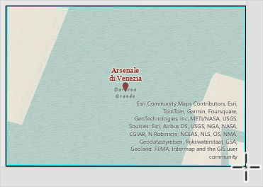
The image below shows the locator map with all extents in the map series displayed as black rectangles and the blue extent indicator highlighting the index feature on each page.

Article ID: 000033320
- ArcGIS Pro 3 1
- ArcGIS Pro 3 3
- ArcGIS Pro 3 2
Get support with AI
Resolve your issue quickly with the Esri Support AI Chatbot.


Related Information
Discover more on this topic
Search for related information
Find training related to this topic
Explore ideas and give feedback
Get help from ArcGIS experts
Start chatting now