HOW TO
Classify and symbolize LAS datasets based on height in ArcGIS Pro
Summary
Ground features in a LAS dataset can be classified into several categories based on their height relative to ground points. The classification is essential for applications such as vegetation analysis, urban planning, and feature extraction. For example, vegetation can be categorized into low, medium, and high categories for detailed analysis of vegetation. This article describes the workflow for classifying and symbolizing LAS datasets based on height in ArcGIS Pro.
Procedure
Note:
This workflow requires the 3D Analyst license.
- Open the ArcGIS Pro project containing the LAS dataset.
Note:
For instructions to find and use the geoprocessing tool, refer to ArcGIS Pro: Find a geoprocessing tool.
- Assign ground points in the LAS dataset to a specific class code using the Classify LAS Ground tool.
- In the Classify LAS Ground pane, for Input LAS Dataset, select the LAS dataset layer from the drop-down list.
- For Ground Detection Method, select the preferred method to detect ground points.
- Click Run.
- Reclassify the LAS dataset points based on their height relative to ground points using the Classify LAS By Height tool.
- In the Classify LAS By Height pane, for Input LAS Dataset, select the output from Step 2 in the drop-down list.
- For Height Classification, configure and specify Class Code and Height to distinguish features as required, or leave the parameter as default.
- Click Run.
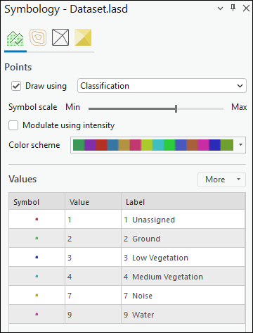
- Symbolize the LAS dataset based on the height.
- In the Contents pane, right-click the LAS dataset layer and select Symbology.
- In the Symbology pane, on Symbolize your layer using points, ensure the Draw using check box is checked.
- Select Classification from the Draw using drop-down list.
- For Symbol scale, modify the scale size as preferred.
- For Color scheme, select the preferred color from the drop-down list.
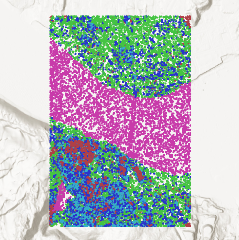
The image below shows the LAS dataset classified based on their height relative to the ground points.
Article ID: 000036161
- ArcGIS Pro
Get support with AI
Resolve your issue quickly with the Esri Support AI Chatbot.


Related Information
Discover more on this topic
Search for related information
Find training related to this topic
Explore ideas and give feedback
Get help from ArcGIS experts
Start chatting now