HOW TO
Change Display Field using ArcGIS Server Services Directory REST API
Summary
When editing features in ArcGIS Online Map Viewer, the display field shows the default field of the layer. A desired display field can be changed to better help visualize the category of the data using ArcGIS Server Services Directory REST API to facilitate more informative visualization of the underlying data categories. It is useful to select a different display field to portray intricate data relationships and patterns clearly which helps make informed decision processes and understand geographic information being explored.
The image below shows the default display field when selecting the features in ArcGIS Online Map Viewer. In this example, the 'SpringOne' layer displays the 'OBJECTID' field.

Procedure
- Log into ArcGIS Online with administrator credentials.
- On the My Content tab, click the hosted feature layer. In this example, 'SpringOne'.
- Scroll to the bottom of the page and click View at the URL section. This opens the ArcGIS REST Services Directory.

- Click Admin to access the service with administrator privilege.
- Click the layer. In this example, the 'Springs' layer.

- Scroll down to the bottom of the page, and click Update Definition.

- Search for displayField using Ctrl + F on the keyboard. Enter the field to display in the displayField parameter. In this example 'FType' is entered.

- Search for lasteditdate using Ctrl + F on the keyboard. In the first line of 'lasteditdate', remove the numbers and replace them with quotation marks with a blank space between the quotation marks.
- Click Update Layer Definition.

- Click Close and pressing F5 on the keyboard to refresh the page.
- Click Open In Map Viewer.
- Click Edit
 on the Settings (light) toolbar.
 - Click Select under Edit features in the Editor pane.
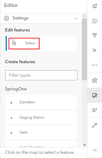
- Select a feature on the map to view the display field.
The image below shows the layers displaying values from the 'FType' field.

Article ID: 000029884
- ArcGIS Online
Get support with AI
Resolve your issue quickly with the Esri Support AI Chatbot.


Related Information
Discover more on this topic
Search for related information
Find training related to this topic
Explore ideas and give feedback
Get help from ArcGIS experts
Start chatting now