HOW TO
Categorize Survey123 field geopoints in ArcGIS Online
Summary
Geopoints collected from ArcGIS Survey123 can be categorized by configuring the symbology of the survey’s point feature layer within the web map in ArcGIS Online. The web map with the configured point symbology can also be linked to the survey on the field app so that previously submitted geopoints may be visible to field workers.
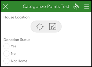
This article provides two workflows to categorize the geopoints. In this example, the House Location geopoints of the survey are categorized based on ‘Yes’, ‘No’, and ‘Not Home’ answers to the Donation Status question.
Procedure
Categorize geopoints in the ArcGIS Online web map
Symbolize the survey’s point feature layer using unique symbology in the web map.
- Create a web map with the survey’s point feature layer in ArcGIS Online.
- Sign in to ArcGIS Online and navigate to the survey folder on the My Content page.
- Click the hosted feature layer item in the folder (not the ‘form’ or ‘results’ view layers). In this example, the 'Categorize points test' hosted feature layer is selected.

- On the item details page, click Open in Map Viewer.
- Configure the symbology of the point feature layer with unique symbols.
- In Map Viewer, on the Contents (dark) toolbar, click the point feature layer.
- In the Properties pane on the Settings (light) toolbar, under Symbology, click Edit layer style.

- Click Field in the Choose attributes section and select the field with the category values to determine the color or style of the points. In this example, the Donation Status field is selected.


- Click Add.
- Ensure the Types (unique symbols) style is selected. The points on the map are categorized based on the answer selected in the survey question. In this example, the points are uniquely colored based on ‘Yes’, ‘No’, and ‘Not Home’ answers on the map.

- Click Style options to further configure the style of the points, if necessary, and click Done.
- Click Save as on the Contents toolbar. Specify a name and location for the web map and click Save.
The web map is saved, and a point is automatically placed on the web map with the configured symbology when a new survey entry is submitted.
Display categorized geopoints in the Survey123 field app
To view existing categorized geopoints on the Survey123 mobile app, link the web map to the survey using Link Content in ArcGIS Survey123 Connect.
- Refer to the workflow above to create a web map of the geopoints using unique symbology in ArcGIS Online.
- Refer to Steps 1 through 4 in the document, ArcGIS Survey123: Link an online map to a survey.
- Click Publish survey
 .
. - On the Survey123 field app, browse to the full-screen map view of the geopoint question.
- Click the basemap selector and select the newly linked web map.


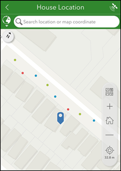
Shown below is the linked web map set as the basemap for the survey’s geopoint question, and existing geopoints from previous submissions are displayed.
Note:
Refer to ArcGIS Survey123: Geopoint symbology to display a custom symbol for the point marker on the map in the Survey123 mobile app. Refer to ArcGIS Survey123: Geometry symbology to add styling for geotrace and geoshape questions in the survey.
Article ID: 000015578
- ArcGIS Online
- ArcGIS Survey123 Field App iOS
- ArcGIS Survey123 Field App Android
- ArcGIS Survey123 Connect
Get support with AI
Resolve your issue quickly with the Esri Support AI Chatbot.


Related Information
Discover more on this topic
Search for related information
Find training related to this topic
Explore ideas and give feedback
Get help from ArcGIS experts
Start chatting now