HOW TO
Calculate wind-induced vibration risk scores for buildings using Arcade in the ArcGIS Enterprise portal and ArcGIS Online
Summary
Calculating wind-induced vibration risk scores helps evaluate a building's structural integrity, occupant comfort, and long-term maintenance needs. For example, a residential tower near the coast may sway during storms, requiring an assessment to improve stability and safety.
This article describes the workflow to calculate wind-induced vibration risk scores for buildings using Arcade in the ArcGIS Enterprise portal and ArcGIS Online.
Procedure
- Log in to the ArcGIS Enterprise portal or ArcGIS Online and click Content > My Content.
- Click the hosted feature layer to open the item page.
- Add a new string field. Refer to Portal for ArcGIS: Add a field or ArcGIS Online: Add a field for instructions. In this example, a new field, 'Vibration_Risk_Score', is added to the attribute table with three existing fields named 'Building_Height', 'Building_Shape', and 'Wind_Exposure'.
- Open the Arcade window. Refer to Portal for ArcGIS: Calculate values for a field from the item page or ArcGIS Online: Calculate values for a field from the item page for instructions.
- In the Expression box, specify the following Arcade expression:
- Retrieve the building height from the dataset.
var height = $feature["Building_Height"];
- Define the shape factor based on the building type.
// Example: 1.2 for rectangular, 1.5 for cylindrical, 1.8 for irregular shapes
var shapeFactor = Decode($feature["Building_Shape"],
    "Rectangular", 1.2,
    "Cylindrical", 1.5,
    "Irregular", 1.8,
    1.2 // Default value
);
- Define the wind exposure factor based on the surrounding environment.
// Example: 1.0 for dense urban, 1.3 for suburban, 1.7 for open terrain
var windExposure = Decode($feature["Wind_Exposure"],
    "Dense Urban", 1.0,
    "Suburban", 1.3,
    "Open Terrain", 1.7,
    1.3 // Default value
);
- Calculate the vibration risk score.
var vibrationRisk = height * shapeFactor * windExposure;
- Normalize the risk score to a scale of 0-100.
var normalizedRisk = Min(vibrationRisk, 100);
- Return the final vibration risk score.
Round(normalizedRisk, 2);
The code block below shows the example of the full working script:
var height = $feature["Building_Height"];

// Example: 1.2 for rectangular, 1.5 for cylindrical, 1.8 for irregular shapes
var shapeFactor = Decode($feature["Building_Shape"],
    "Rectangular", 1.2,
    "Cylindrical", 1.5,
    "Irregular", 1.8,
    1.2 // Default value
);

// Example: 1.0 for dense urban, 1.3 for suburban, 1.7 for open terrain
var windExposure = Decode($feature["Wind_Exposure"],
    "Dense Urban", 1.0,
    "Suburban", 1.3,
    "Open Terrain", 1.7,
    1.3 // Default value
);

var vibrationRisk = height * shapeFactor * windExposure;

var normalizedRisk = Min(vibrationRisk, 100);

Round(normalizedRisk, 2);
- Click OK.
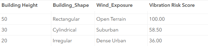
The attribute table below shows the calculated vibration risk scores.
Article ID: 000034888
- ArcGIS Online
- Portal for ArcGIS
- ArcGIS Enterprise 11 3
- ArcGIS Enterprise 11 2
- ArcGIS Enterprise 11 4
Get support with AI
Resolve your issue quickly with the Esri Support AI Chatbot.


Related Information
Discover more on this topic
Search for related information
Find training related to this topic
Explore ideas and give feedback
Get help from ArcGIS experts
Start chatting now