HOW TO
Calculate the area of a vector dataset based on raster values using the Tabulate Area tool
Summary
ArcGIS Pro can calculate the area of a vector dataset using raster values with the Tabulate Area tool. For example, the area of land use categories by districts can be calculated using the raster values relative to a vector dataset to understand the impact of population growth in the city.
Note:
Depending on the dataset size, calculating the area of a vector dataset using raster values may consume a lot of time and computer memory.
Procedure
This workflow describes how to calculate the area of land use from a land use raster relative to the feature class of country subdivisions in Puerto Rico using the Tabulate Area tool.
Note:
The Spatial Analyst extension must be installed and enabled to use the Tabulate Area geoprocessing tool. Refer to ArcGIS Pro: Enabling the Spatial Analyst extension for more information.
- In ArcGIS Pro, add the classified land use dataset. This is a raster dataset classified in 10 classes.
- Add the country subdivisions polygon shapefile. This is a vector dataset.
- On the Analysis tab, click the Tools icon in the Geoprocessing group to open the Geoprocessing pane.
- In the Geoprocessing pane, search for and select the Tabulate Area Tool.
- In the Tabulate Area pane, set the parameters.
- For Input raster or feature zone data, select the land use raster dataset added in Step 1.
- The Zone field is set to Value by default.
- For Input raster or feature class data, select the country subdivision polygon shapefile added in Step 2.
- For Class field, select the field name from the polygon shapefile. This field is used to calculate the area of the raster dataset.
- For Output table, specify the output geodatabase or folder for the output table.
- Click Run.
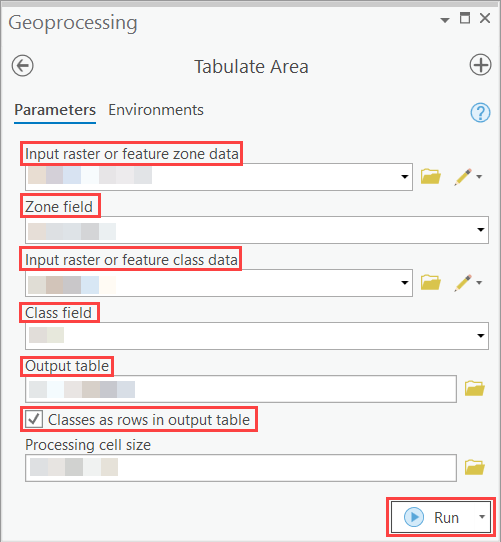
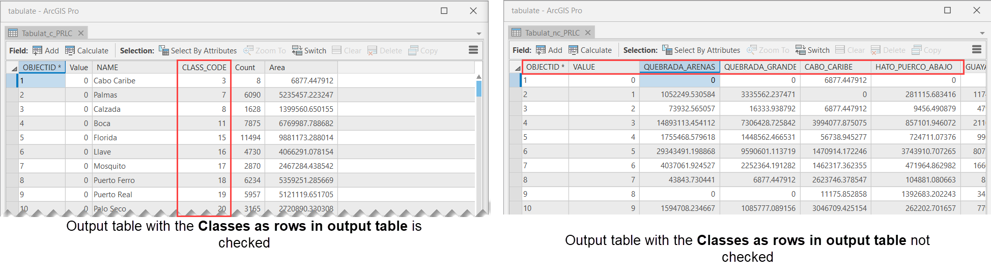
Note:
To determine the area of each class per zone, check the Classes as rows in output table check box.
- The Output table is added in the Content pane. Right-click on the resulting output table to examine the contents. The area in square meters of the land use by pixel counts is calculated for each type of land use for each country subdivision.
Article ID: 000024857
- ArcGIS Pro 2 7 x
- ArcGIS Pro 2 x
Get support with AI
Resolve your issue quickly with the Esri Support AI Chatbot.


Related Information
Discover more on this topic
Search for related information
Find training related to this topic
Explore ideas and give feedback
Get help from ArcGIS experts
Start chatting now