HOW TO
Calculate raster percentages within a buffer and correlate with tabular data in ArcGIS Pro
Summary
Accurate calculation of area percentages of raster within a buffer area is important for detailed spatial analyses, such as identifying zones at risk based on environmental factors. Buffer areas are often used in these workflows to define zones of interest. This article outlines the workflow to calculate percentages of raster datasets within a buffer distance and correlate the values with existing tables for further analysis in ArcGIS Pro.
Procedure
Note:
This workflow requires the ArcGIS Pro Advanced license.
- Open the ArcGIS Pro project.
Note:
For instructions to find and use the geoprocessing tool, refer to ArcGIS Pro: Find a geoprocessing tool.
- Clip the overlapped raster feature layer within the buffer layer using the Extract by Mask tool.
- Convert the extracted raster feature layer to a polygon feature layer using the Raster to Polygon tool.
- Compute the values using the Tabulate Intersection tool to generate the total buffer area in a table format.
- In the Tabulate Intersection pane, for Input Zone Features, select the buffer layer.
- For Zone Fields, select a field from the drop-down list to define the zones. In this example, BUFF_DIST is selected.
- For Input Class Features, select the polygon feature layer.
- Leave the other parameters as default. Click Run.
- Join the attribute values between the newly created table and the polygon feature layer based on the spatial relationship using the Add Spatial Join tool.
- Create a new field in the polygon feature layer. Refer to ArcGIS Pro: Create a field and apply a domain and default value for instructions. In this example, the field is named PERCENTAGE.
- Calculate the area percentages of the polygon feature layer within the buffer area using the Calculate Field tool.
- In the Calculate Field pane, for Input Table, select the polygon feature layer.
- For Field Name (Existing or New), select the new field created in Step 6.
- For Expression Type, select Python.
- In the Expression section, specify the following expression. Replace <area> with the field containing the area of the polygon feature layer and <Total values> with the total value of the buffer area.
<area>/<Total values> *100
The Calculate Field pane below shows the expressions used to calculate the area percentages of the feature layer.
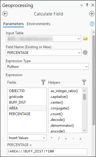
- Click OK.
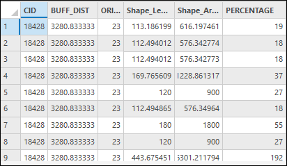
The attribute table below shows the percentage values in the PERCENTAGE field.
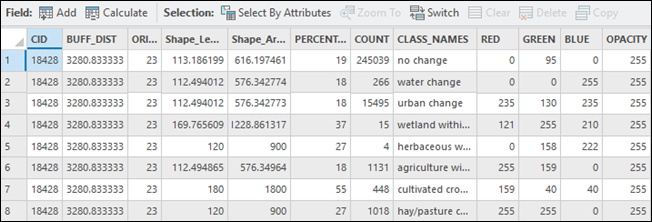
- Correlate the attribute values from the existing table with the output in Step 7 using the Add Join tool.
Note:
Optionally, to modify the table without altering the original record, export the records to a new table. Refer to ArcGIS Pro: Export a table from a map for instructions.
The attribute table below displays the raster percentage within the buffer area and the attribute values from the correlated table.
Article ID: 000035350
- ArcGIS Pro
Get support with AI
Resolve your issue quickly with the Esri Support AI Chatbot.


Related Information
Discover more on this topic
Search for related information
Find training related to this topic
Explore ideas and give feedback
Get help from ArcGIS experts
Start chatting now