HOW TO
Calculate and evaluate urban heat risk using Arcade in the Enterprise portal and ArcGIS Online
Summary
Calculating urban heat risk helps identify areas vulnerable to extreme temperatures, enabling better urban planning, targeted green infrastructure investment, and improved public health strategies to mitigate heat-related risks. For example, a city identifies a high heat risk neighborhood with dense buildings and little greenery, then plants trees to reduce temperatures.
Complete the workflow provided to calculate and evaluate urban heat risk based on building density, surface type, and green coverage using Arcade in the ArcGIS Enterprise portal and ArcGIS Online.
Procedure
- Log in to the ArcGIS Enterprise portal or ArcGIS Online and click Content > My Content.
- Click the hosted feature layer to open the item page.
- Add a new string field. Refer to Portal for ArcGIS: Add a field or ArcGIS Online: Add a field for instructions. In this example, a new field, Risk_Category, is added to the attribute table with three existing fields named Surface_Type, Green_Coverage, and Building_Density.
- Open the Arcade window. Refer to Portal for ArcGIS: Calculate values for a field from the item page or ArcGIS Online: Calculate values for a field from the item page for instructions.
- In the Expression box, specify the Arcade expression.
- To specify the necessary variables to assign the required fields:
var buildingDensity = $feature.Building_Density; // % of built-up area (0-100)
var surfaceMaterial = $feature.Surface_Type; // "Concrete", "Asphalt", "Grass", "Water"
var greenCoverage = $feature.Green_Coverage; // % of area covered by greenery (0-100)
- To create a variable selection for the heat absorption score based on the surface type:
var materialScore = When(
    surfaceMaterial == "Concrete", 40,
    surfaceMaterial == "Asphalt", 50,
    surfaceMaterial == "Grass", 10,
    surfaceMaterial == "Water", 0,
    25 // Default for unknown materials
);
- To specify the calculation to normalize the green impact score:
var greenImpact = (100 - greenCoverage) * 0.5;
- To calculate the final heat risk score:
var heatRiskScore = Min(100, buildingDensity * 0.5 + materialScore + greenImpact);
- To create a variable selection for the risk level categorization:
var riskCategory = When(
    heatRiskScore >= 80, "Very High",
    heatRiskScore >= 60, "High",
    heatRiskScore >= 40, "Moderate",
    heatRiskScore >= 20, "Low",
    "Very Low"
);
- To return the heat risk category:
return riskCategory;
The code block below demonstrates the full working script.
var buildingDensity = $feature.Building_Density; // % of built-up area (0-100)
var surfaceMaterial = $feature.Surface_Type; // "Concrete", "Asphalt", "Grass", "Water"
var greenCoverage = $feature.Green_Coverage; // % of area covered by vegetation (0-100)

var materialScore = When(
    surfaceMaterial == "Concrete", 40,
    surfaceMaterial == "Asphalt", 50,
    surfaceMaterial == "Grass", 10,
    surfaceMaterial == "Water", 0,
    25 // Default for unknown materials
);

var greenImpact = (100 - greenCoverage) * 0.5;

var heatRiskScore = Min(100, buildingDensity * 0.5 + materialScore + greenImpact);

var riskCategory = When(
    heatRiskScore >= 80, "Very High",
    heatRiskScore >= 60, "High",
    heatRiskScore >= 40, "Moderate",
    heatRiskScore >= 20, "Low",
    "Very Low"
);

return riskCategory;
- Click OK.
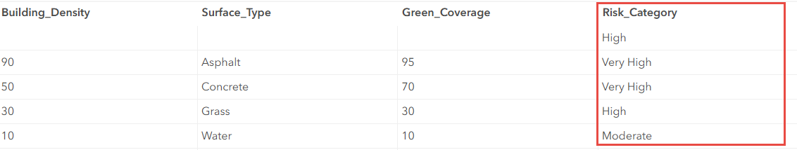
The image below shows the calculated urban heat risk based on building density, surface type, and green coverage.
Article ID: 000034799
- ArcGIS Online
- Portal for ArcGIS
- ArcGIS Enterprise 11 3
- ArcGIS Enterprise 11 2
- ArcGIS Enterprise 11 4
Get support with AI
Resolve your issue quickly with the Esri Support AI Chatbot.


Related Information
Discover more on this topic
Search for related information
Find training related to this topic
Explore ideas and give feedback
Get help from ArcGIS experts
Start chatting now