HOW TO
Auto-populate concatenating fields using attribute rules in ArcGIS Pro
Summary
In ArcGIS Pro, the Field Calculator is used to concatenate fields in a table. When working in a continuous data collection project, a feature class and its attribute table are constantly updated with new features and attributes, or there may be changes made to the existing feature attributes in the attribute table. The attribute rules allow users to auto-populate these feature attributes in the concatenating fields without using the Calculate Field tool.
In this article, a new field called 'FullADRS' uses an attribute rule to auto-populate the concatenated attributes each time a new feature is added to or updated in the 'Street' and 'City' fields.
Procedure
- Open the ArcGIS Pro project.
- In the Catalog pane, browse to and right-click the feature class, and click Manage.
- In the Feature Class Properties window, in the Manage section, check the Global IDs and Editor tracking check boxes. Click OK at the bottom-right of the window.
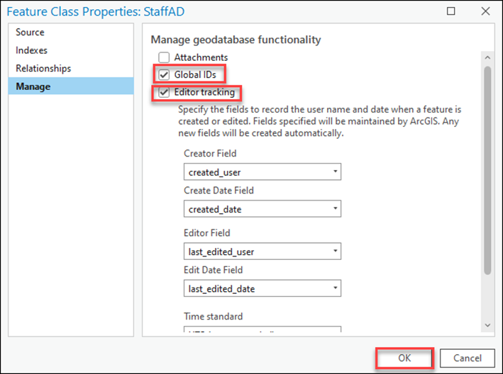
Note:
The dataset requires Global IDs to add an attribute rule.
- Right-click the feature layer in the Contents pane and click Data Design > Attribute Rules.
- Click the Add Rule drop-down and select Add Immediate Calculation Rule.
- Specify a Rule Name. For this example, ‘New Rule’ is used.
- Select the Field to use. For this example, ‘FullADRS' is used.
- In the Expression box, type the following Arcade expression:
var <variable_name1> = <field_name1>;
var <variable_name2> = <field_name2>
return Concatenate([<variable_name1>, <variable_name2>], ' ');
- Replace <variable_name1> and <variable_name2> with the desired variable name. In this example, ‘street’ and ‘city’ are used.
- Replace <field_name1> and <field_name2> with the name of each individual field to be concatenated from the Fields list. In this example, 'Street' and 'City' are used.
- Under Triggers, check the Insert and Update check box.
- On the Attribute Rules tab, in the Attribute Rules group, click Save.

The attribute table below displays an attribute rule that auto-populates the concatenated field when the feature information is updated.

Article ID: 000028525
- ArcGIS Pro 3 0
- ArcGIS Pro 2 8 x
- ArcGIS Pro 2 7 x
- ArcGIS Pro 2 x
Get support with AI
Resolve your issue quickly with the Esri Support AI Chatbot.


Related Information
Discover more on this topic
Search for related information
Find training related to this topic
Explore ideas and give feedback
Get help from ArcGIS experts
Start chatting now