HOW TO
Append tapestry information to address points to determine the percentage of a dominant segment in ArcMap
Summary
In a large tabular dataset of addresses, it is useful to apply tapestry information to address points so the percentage of the dominant tapestry segment can be determined. For example, when integrating consumer traits with residential characteristics to identify markets and classify neighbourhoods. For more information on tapestry segmentation in U.S. residential areas, refer to Esri Demographics: Tapestry Segmentation.
Procedure
This article describes how to apply a tapestry segment (in this example, customers) to address points to determine the percentage of the segment per sub-region (in this example, the sub-region of Worcester) in ArcMap.
- In the Business Analyst toolset, use Customer Setup Wizard to geocode addresses in the dataset, and apply a tapestry code to the resulting customer points layer.
Note:
This process consumes credits.
- On the Business Analyst toolbar, click Business Analyst > Customer Setup. This opens the Customer Setup Wizard window.
- Perform Steps 11 through 17, as outlined in ArcMap: Geocoding your stores and customers.
- Check the Append segmentation code to address records. option. Click Next.
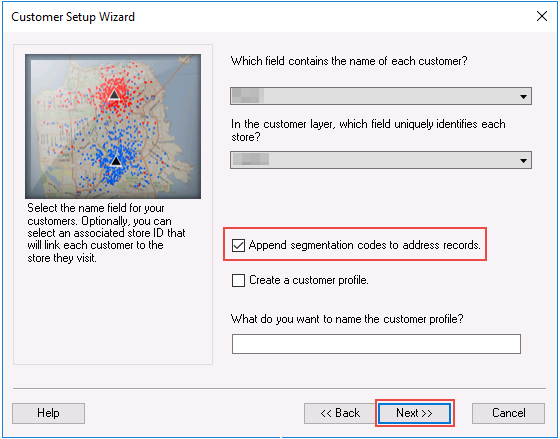
- Name the customer points layer and click Finish. The customer points layer is created. The tapestry code is shown in the attribute table of the customer points layer.
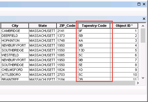
- Select and export the customer point features as an Excel file based on the desired sub-region.
- Open the attribute table of the customer points layer.
- Use the Select By Attribute tool to select customer points from a state, region or sub-region. In this example, customer points are selected from the Worcester sub-region.
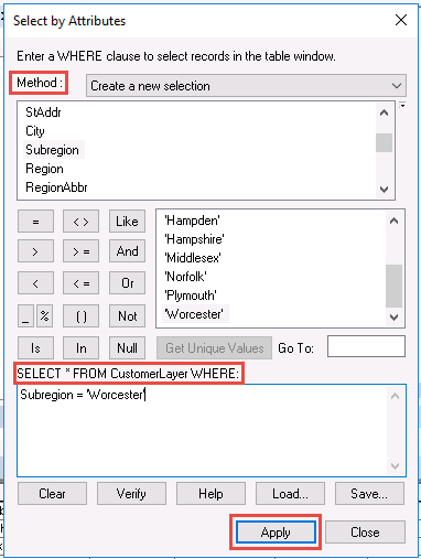
- Use the Table to Excel tool to export the selected customer point features as an Excel file. Check the option to use field aliases as column headers.
- In Microsoft Excel, open the .xls file, and use the COUNTIF function to calculate the percentage of customers in the sub-region.
=COUNTIF(range, criteria)/COUNTA(range)
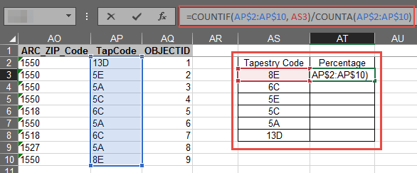
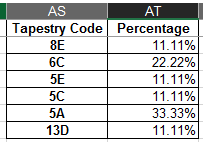
The image shows the percentage of the tapestry code segmentation in the Worcester sub-region.
Article ID: 000018970
- ArcGIS Business Analyst Desktop
- ArcMap 10 7
- ArcMap 10 8
Get support with AI
Resolve your issue quickly with the Esri Support AI Chatbot.


Related Information
Discover more on this topic
Search for related information
Find training related to this topic
Explore ideas and give feedback
Get help from ArcGIS experts
Start chatting now