Frequently asked question
What is the difference between the Viewshed and Geodesic Viewshed tools in ArcGIS Pro?
In ArcGIS Pro, both the Viewshed and Geodesic Viewshed tools determine the raster surface locations visible to a set of observer features and are available with a Spatial Analyst or 3D Analyst license. These tools can be accessed from the geoprocessing toolbox on the ArcGIS Pro Analysis ribbon tab.
While both tools share many similar general functions and configuration parameters, they have key differences and additional parameters that are described in the table below.
| Viewshed | Properties | Geodesic Viewshed |
| The planar method is used to calculate visibility, assumes the earth is flat, with optional adjustments for earth curvature. This correction is approximate, and assumes uniform curvature across the earth's surface. | Computation method | The geodesic method with a 3D model is used to calculate visibility. This accounts for the earth's irregular shape as an ellipsoid, providing a more accurate representation of local curvature at the analyzed locations. |
| This tool is best suited for use in local or small-scale projects where the area of interest does not require consideration of the earth's curvature. | Usage | This tool is best suited for use in long-distance or large-scale projects where the curvature of the earth plays a significant role in visibility analysis such as regional or global studies. |
| This tool is best aligned with the projected coordinate system, which is ideal for small-scale areas and reduces distortions. | Coordinate system | This tool calculates visibility based on the geographic coordinate system and its associated geoid or datum. |
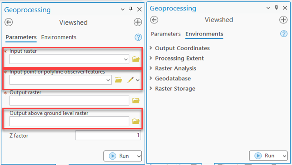
| The observer offset parameter is not available and only honors fixed field names from the input observer feature attribute table. | Observer offset | The observer offset parameter applies a one-meter height offset to observer locations by default. |
| The coefficient of the refraction of visible light in air is not accounted for by default. However, this can be adjusted by applying the curvature correction. | Refractivity coefficient | The coefficient of the refraction of visible light in air is accounted for by default. |
Characteristics of the Viewshed and Geodesic Viewshed tools
The Viewshed tool provides essential parameters and configurations for basic visibility analysis to determine the visible areas from a set of observer points within a defined area. This tool considers factors such as the location of observer points, elevation data, and observer altitude.
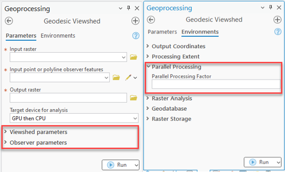
The Geodesic Viewshed tool provides more advanced configuration settings than the Viewshed tool. This includes additional settings such as Viewshed parameters, Observer parameters, and the Parallel Processing Factor environment.
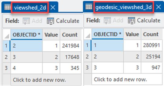
Differences in output visibility raster count values between the tools
The output visibility rasters are different because each tool calculates visibility using a different algorithm. The Viewshed tool uses the planar method, which assumes the Earth's surface is flat and generates generalized results with a simpler configuration. Meanwhile, the Geodesic Viewshed tool uses the geodesic method and generates more precise and detailed results. This tool accurately models the true distances and angles between observer points and the visible location across the Earth's curve through additional configurations.
The image below shows the differences in output visibility raster count values between the Viewshed and Geodesic Viewshed tools.
Article ID: 000034272
- ArcGIS Pro 3 3
- ArcGIS Pro 3 2
- ArcGIS Pro 3 4
Get support with AI
Resolve your issue quickly with the Esri Support AI Chatbot.


Related Information
Discover more on this topic
Search for related information
Find training related to this topic
Explore ideas and give feedback
Get help from ArcGIS experts
Start chatting now