Frequently asked question
Is it possible to change the Shape_Length field unit measurement in ArcGIS Pro?
The Shape_Length field for a geodatabase feature class is generated automatically and managed by ArcGIS. Therefore, the field cannot be edited manually. As a workaround, create a new field, and use the Calculate Geometry tool to populate the new field with the Shape_Length field values in the desired unit of measurement. Complete the steps below to do so:
Note:
To determine the unit of measurement of the Shape_Length field in ArcGIS Pro, right-click the feature class in the Contents pane, and click Properties. In the Layer Properties: <feature_class> window, click Source, scroll to the Spatial Reference section, and identify the Linear Unit.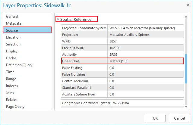
- Add a new Double type field to the attribute table. Refer to Steps 1 through 4 in ArcGIS Pro: Create a field and apply a domain and default value for instructions to do so.
- Specify the new field's name in the Field Name column. In this example, the field name is Length.
- Specify an alias in the Alias column. In this example, the alias is Length.
- Select Double for Data Type.
- Save the edits. Refer to ArcGIS Pro: Save edits made in the Fields view for steps to do so.
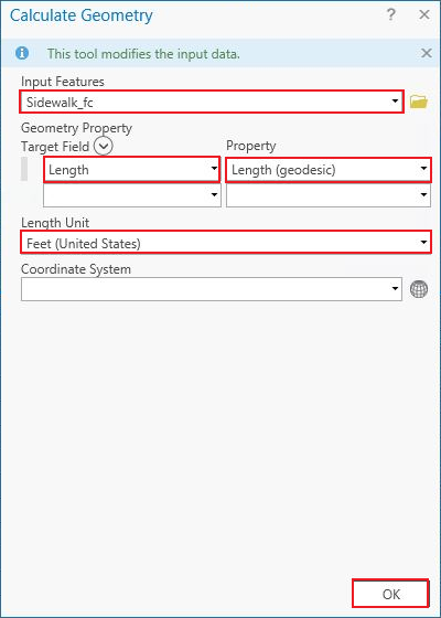
- Populate the new field with the Shape_Length field values in the desired unit. In this example, the Shape_Length field's Linear Unit is Meters (1.0), and the new desired unit is Feet (United States).
- Right-click the header of the created field in Step 1, and click Calculate Geometry. The Calculate Geometry window opens.
- In the Calculate Geometry window, select the desired feature class for Input Features.
- Under Geometry Property, the new field created in Step 1, Length, is populated automatically under Target Field. Click the Property drop-down menu, and select Length (geodesic).
- For Length Unit, select the desired unit. In this example, Feet (United States) is selected.
- Click OK.
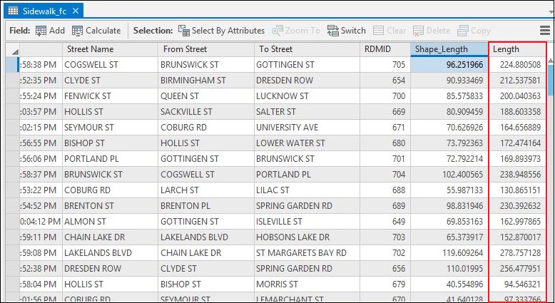
The following attribute table displays the new field with the populated Shape_Length field values in Feet (United States).
Note:
Optionally, it is possible to project the layer in the coordinate system that uses a desired linear unit of measurement using the Project tool. For example, if the layer's Projected Coordinate System is NAD 1983 HARN (Meters), use the Project tool to specify the Output Coordinate System to NAD 1983 HARN (US Feet). Ensure the Map Frame is in the same coordinate system as the layer. Refer to ArcGIS Pro: Specify the coordinate systems of maps and scenes for more information.

If the Shape_Length field is in angular unit of measurement, use the Project tool to project the layer in a coordinate system that uses linear unit of measurement. Refer to FAQ: What is the unit of measurement used by the Shape_Length field in attribute tables? for more information on the coordinate systems that use angular or linear unit of measurement.
Article ID: 000025763
- ArcGIS Pro 2 8 x
- ArcGIS Pro 2 7 x
- ArcGIS Pro 2 x
Get support with AI
Resolve your issue quickly with the Esri Support AI Chatbot.


Related Information
Discover more on this topic
Search for related information
Find training related to this topic
Explore ideas and give feedback
Get help from ArcGIS experts
Start chatting now