Frequently asked question
Can shared boundary be retained after dissolving two polygon features in ArcGIS Pro?
No. Dissolving polygon features combines adjacent features by removing the shared boundaries to create a unified shape. This behavior is by design and is commonly used to generalize features based on attribute values.
However, alternative workflows are available to retain the shared boundary visually by merging the feature data from the features into a single record in the attribute table using the Merge tool from the Modify Features pane.
Convert the polygons to lines
Note:
This workflow generates features without the polygon fill.
- Open the ArcGIS Pro project.
Note:
This tool requires the ArcGIS Pro Advanced license.
- Convert the polygons to lines using the Polygon To Line tool.
- On the Analysis tab, in the Geoprocessing group, click Tools.
- In the Geoprocessing pane, search for and click Polygon To Line.
- In the Polygon To Line pane, for Input Features, select one of the polygon feature layers from the drop-down list.
- For Output Feature Class, specify a location.
- Uncheck the Identify and store polygon neighboring information check box.
- Click Run.
- Merge the converted line features using the Merge tool.
- On the Edit tab, in the Features group, click Modify.
- In the Modify Features pane, search for and click Merge.
- Select the line features on the map to be merged. Optionally, select the output line feature layer from Step 2.
- Click Merge and save the edits.
Enable z-values for the polygons
Note:
This workflow generates an additional record from the merged features instead of overwriting the existing features’ data for more flexibility.
- Open the ArcGIS Pro project.
- Enable the z-values for the polygons.
- On the Project tab, click Options.
- On the Options dialog box, click the Editing tab.
- Expand the General section and check the Merge z-aware polygons and allow non-planar geometry check box under Geometry.
- Click OK.
- In the Contents pane, right-click the polygon feature layer to export and click Data > Export Features. Refer to ArcGIS Pro: Export Features (Conversion) for more information.
- On the Environments tab, ensure Enabled is selected for Output has Z Values.
- Edit the new exported feature layer vertices.
- On the Edit tab, in the Tools group, click Edit Vertices.
- Select one of the polygon features on the map.
- In the Edit Vertices pane, change the z-values from 0 to 1.
- Save the edits.
- Merge the exported polygon features using the Merge tool.
- On the Edit tab, in the Features group, click Modify.
- In the Modify Features pane, search for and click Merge. Click the New Feature tab.
- Select the polygon features on the map to be merged.
- Check the Keep original features check box and uncheck the Use Template check box.
- Click Merge and save the edits.
Note:
To view the shared boundary on the map, change the feature symbology or set the polygon fill to No color.
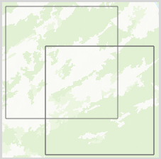
The map below shows the two polygon features with visible shared boundaries.
Article ID: 000035519
- ArcGIS Pro
Get support with AI
Resolve your issue quickly with the Esri Support AI Chatbot.


Related Information
Discover more on this topic
Search for related information
Find training related to this topic
Explore ideas and give feedback
Get help from ArcGIS experts
Start chatting now