Frequently asked question
Can shapefiles display image attachments in ArcGIS Pro pop-ups?
No, shapefiles cannot display attachments in ArcGIS Pro pop-ups due to their limited functionality; this functionality is only supported in feature classes. Shapefiles are designed for basic data storage and are commonly used for easy sharing without requiring a geodatabase.
To display images in pop-ups, either use web-based image URLs in the attribute table or convert the shapefiles to feature classes that support attachments. Follow the steps below to configure these display alternatives.
Use web-based image URLs
Note:
This method requires publicly accessible web-based image URLs, as local image files are not supported.
- Open the ArcGIS Pro project containing the shapefile.
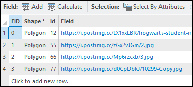
- Add a new field to the shapefile attribute table and enter the preferred image URLs to the field.
- In the Contents pane, right-click the shapefile and click Attribute Table.
- In the attribute table, click Add Field to open the fields view.
- Configure the new field with the Text data type. Refer to ArcGIS Pro: Create a field and apply a domain and default value for instructions and more information.
- On the Fields tab, in the Manage Edits group, click Save. Close the Fields view.
- In the attribute table, double-click each cell in the newly added field and enter the corresponding image URL.
- On the Edit tab, in the Manage Edits group, click Save to apply the changes. Close the attribute table.
- Configure pop-ups to display images based on the image URL field.
- In the Contents pane, right-click the shapefile layer and click Configure Pop-ups.
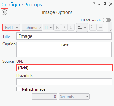
- In the Configure Pop-ups pane, click the Image button.
- Hover over the Image element and click the Edit pop-up element button
 to edit the image element.
 - For Source, click the URL text box. In the Field drop-down list, select the newly created field from Step 2.
- Click Back to apply the changes.
Convert the shapefile to a feature class and enable attachments
- Open the ArcGIS Pro project containing the shapefile.
- Convert the shapefile to a feature class using the Export Features or Feature Class To Geodatabase tools. To locate the tool, refer to ArcGIS Pro: Find a geoprocessing tool.
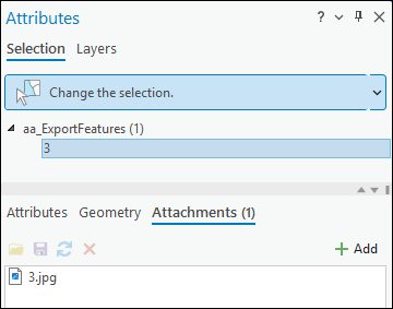
- Enable attachments for the exported feature class using the Enable Attachments tool.
- Add images stored on the local machine as attachments. Refer to ArcGIS Pro: Add an attachment for instructions.
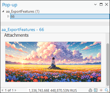
The image below shows the image attachment displayed in the ArcGIS Pro pop-up.
Article ID: 000037456
- ArcGIS Pro
Get support with AI
Resolve your issue quickly with the Esri Support AI Chatbot.


Related Information
Discover more on this topic
Search for related information
Find training related to this topic
Explore ideas and give feedback
Get help from ArcGIS experts
Start chatting now