Frequently asked question
Can Revit files be directly imported to ArcGIS CityEngine?
No, it is not possible to directly import an Autodesk Revit (RVT) file to ArcGIS CityEngine.
Building information modeling (BIM) data files, such as Revit, are used to create and manage 3D models of structures and buildings. This file enables architects, engineers, and other professionals to collaborate on a project by storing detailed information such as building components, roadways, and railways. ArcGIS CityEngine allows only buildingSMART IFC and Autodesk DWG files to be imported as BIM data. There is currently no option to import Autodesk Revit (RVT) files, which is a known limitation.
However, it is possible to convert the Revit file to a file geodatabase feature class using the BIM File To Geodatabase tool in ArcGIS Pro. The file geodatabase can then be imported to ArcGIS CityEngine for further analysis, including the creation of realistic 3D models and simulations.
- Create a project in ArcGIS Pro.
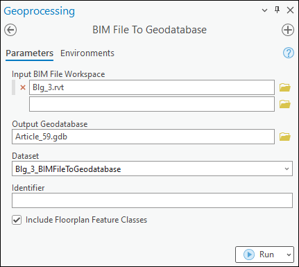
- Import the Revit file as the BIM file workspace into a single geodatabase feature dataset using the BIM File To Geodatabase tool. Refer to ArcGIS Pro: Convert a BIM file workspace to a geodatabase for instructions. In this example, the BIM file workspace named Blg_3.rvt is used.
- In ArcGIS CityEngine, import the output file geodatabase in Step 2 to a scene. Refer to ArcGIS CityEngine: Import by dialog for instructions.
Note:
Alternatively, RVT files can be exported as DWG, DXF, OBJ, and IFC formats from Autodesk Revit, which is supported by ArcGIS CityEngine. Refer to ArcGIS CityEngine: File types for more information.
Article ID: 000032670
- ArcGIS Pro 3 1
- ArcGIS Pro 3 3
- ArcGIS Pro 3 2
- ArcGIS CityEngine 2022
- ArcGIS CityEngine 2023
Get support with AI
Resolve your issue quickly with the Esri Support AI Chatbot.


Related Information
Discover more on this topic
Search for related information
Find training related to this topic
Explore ideas and give feedback
Get help from ArcGIS experts
Start chatting now