Frequently asked question
Can GPX files be opened in ArcGIS Pro?
It is possible to directly open GPX files in ArcGIS Pro with the Data Interoperability extension. A GPX file, also known as a GPS Exchange Format file, is a text file in XML format with geographic information such as waypoints, tracks, routes, and coordinates. Refer to ArcGIS Data Interoperability: Supported Formats for more information on the supported formats available for the ArcGIS Data Interoperability extension. Without the extension however, ArcGIS Pro is incapable of directly reading a GPX file.
Alternatively, ArcGIS Earth can be used, as it supports a wide range of data formats including KML and GPX natively. ArcGIS Earth is an application for visualizing and exploring geospatial content on an interactive 3D globe, both online and offline. Additionally, 3D analyses such as elevation profiles, line of sight analyses, and viewshed analyses can be performed.
To work with GPX data in ArcGIS Pro without the ArcGIS Data Interoperability extension, a GPX file can be converted to features using GPX to Features (Conversion Tools) directly in ArcGIS Pro.
- In ArcGIS Pro, create a new project and add a folder connection in the Catalog pane.
- On the Analysis tab, in the Geoprocessing group, click Tools.
- In the Geoprocessing pane, search for and click the GPX To Features (Conversion Tools).
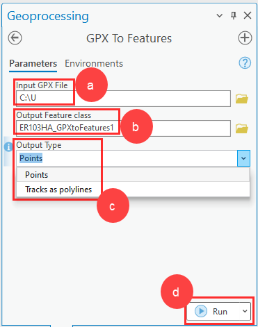
- Configure the following parameters on the Parameters tab of the GPX To Features pane:
- For Input GPX File, select the desired GPX file.
- For Output Feature class, specify the save location.
- For Output Type, select Points or Tracks as polylines.
- Click Run.
Use ArcGIS Earth to export a GPX file as a KML file and convert it to a feature class in ArcGIS Pro.
- Open ArcGIS Earth.
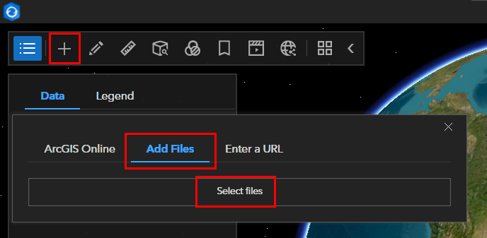
- On the toolbar, click Add data and click Add Files to add local files stored on the machine.
- Click Select files to add the desired GPX file.
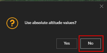
- When prompted to use absolute altitude values, choosing Yes results in the features being extruded to the absolute value. Choosing No results in adjusting the altitude to drape on the ground. If the prompt panel is cancelled, the data is adjusted to drape by default. Refer to ArcGIS Earth: GPX file, for more information.
- Click Expand Table of Contents, right-click the layer, and click Save as.
- Click Set path and select a destination folder to save the layer.
- Save the file in KML format.
- In ArcGIS Pro, open a project and add a folder connection to the folder containing the KML file in the Catalog pane. Refer to ArcGIS Pro: Connect to an existing folder for instructions.
- Expand the folder and right-click the KML file. Click Add To Current Map to add the KML layer to the map.
- Run the KML To Layer (Conversion Tools) tool using the KML file saved in Step 7 as the input file. Refer to ArcGIS Pro: KML To Layer (Conversion) for more information.
- Export the layer to a feature class. Refer to ArcGIS Pro: Export Features (Conversion) for more information. Repeat this step for subsequent layers.
Article ID: 000031926
- ArcGIS Earth
- ArcGIS Pro 3 1
- ArcGIS Pro 3 0
- ArcGIS Pro 3 2
Get support with AI
Resolve your issue quickly with the Esri Support AI Chatbot.


Related Information
Discover more on this topic
Search for related information
Find training related to this topic
Explore ideas and give feedback
Get help from ArcGIS experts
Start chatting now