ERROR
ERROR 000210: Cannot create output <file path>. Failed to execute (LasDatasetToRaster)
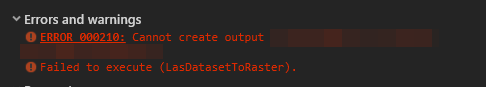
Error Message
Attempting to create a raster from a LAS file using the LAS Dataset To Raster tool fails, with the following error message returned:
Error:
ERROR 000210: Cannot create output <file path>. Failed to execute (LasDatasetToRaster).
Cause
The LAS dataset is projected in a geographic coordinate system instead of a projected coordinate system.
Solution or Workaround
Reproject the LAS dataset to a projected coordinate system using the Extract LAS tool to resolve this issue.
Note:
The Extract LAS tool is only available with a 3D Analyst license.
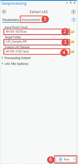
- In ArcGIS Pro, open the Geoprocessing pane, navigate to Toolboxes > 3D Analyst Tools > Point Cloud > Extract LAS.
- In the Extract LAS pane, for Input Point Cloud, select the LAS dataset to process.
- For Target Folder, select the folder to save the output LAS.
- For Output LAS Dataset, select the output LAS dataset referencing the newly created .las files.
- In the Environments tab, under Output Coordinates, select a projected coordinate system for Output Coordinate System by clicking Select coordinate system
 .
. - Click Run.
Article ID: 000027636
Software:
- ArcGIS Pro 2 8 x
- ArcGIS Pro 2 x
Get support with AI
Resolve your issue quickly with the Esri Support AI Chatbot.


Related Information
Discover more on this topic
Search for related information
Find training related to this topic
Explore ideas and give feedback
Get help from ArcGIS experts
Start chatting now