HOW TO
Diagnose performance issues in ArcGIS Online
Summary
When managing an ArcGIS Online environment, performance incidents can arise unexpectedly, impacting user experience and system efficiency. Diagnosing these issues quickly is crucial for maintaining smooth operations. This article walks through key steps and considerations when troubleshooting performance problems in ArcGIS Online.
Procedure
Rule Out Client-Side Issues
Before diving into server-side diagnostics, it’s essential to ensure that the performance issues aren’t caused by client-side factors. Here are some common areas to check:
- Firewalls: Have there been any recent changes to the corporate firewall policy? Sometimes, performance issues correlate with updates in firewall settings or operating system changes that happened concurrently.
- Network Connectivity: Run an internet speed test to rule out network-related issues. If there are persistent connectivity problems, this could be the source of degraded performance.
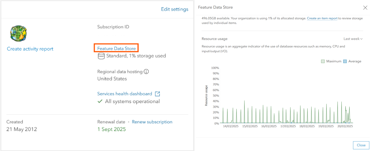
Resource Utilization
Monitoring the usage of system resources such as memory, CPU, and input/output (I/O) is key. Resource utilization provides an aggregate indicator of system health. How often do you notice peaks? If the average values consistently reach high levels, this suggests resource limits are being exceeded. Conversely, if the chart shows low and stable values, the issue may not be resource-related.
- You can find the resource usage in the Organization > Overview tab if you are an administrator in an ArcGIS Online organization. Click the Feature Data Store hyperlink text box shown in the image below to inspect the level of usage for your subscription's computational resources.
- In this example, there is some routine process taking place every six hours that uses at its maximum, approximately 30% of the organization's computing resources.
Investigate Performance Spikes in Resource Usage
Performance degradation often manifests as irregular or regular spikes in resource usage. Understanding the nature of these spikes can provide valuable insights into the root cause.
- Irregular Spikes: Sudden, unpredictable increases in resource demand might be linked to surges in web traffic. It’s possible that certain web maps or feature layers shared publicly are attracting more users or queries than expected.
- Regular Spikes:
- Automated Processes (Notebook Scripts): ArcGIS Online supports notebooks that can be scheduled to run automatically, sometimes as frequently as every 15 minutes. If these scripts are poorly optimized or execute resource-heavy tasks, they could contribute to performance issues.
- Third-Party Applications: Many third-party tools like GeoJobe or VertiGIS work seamlessly with ArcGIS Online, improving workflows and managing content. However, these apps can sometimes be scheduled to run tasks at regular intervals, which could coincide with performance spikes. It's crucial to check their schedule and align it with resource usage trends.
Assess Large Applications and Maps
Web applications, particularly those with extensive filters or large hosted feature layers, can put significant strain on your resources. These applications often send a high volume of queries, leading to resource throttling.
- Request Units: ArcGIS Online limits the number of requests per user through a system called Request Units. A high number of requests in a short period may indicate that certain applications or users are over-consuming resources. Watch the following video at 10:55 to learn more about these request units: ArcGIS Online: Advanced Methods for Managing Hosted Data - Esri Videos: GIS, Events, ArcGIS Products & Industries
- Web Traffic Inspection: You can inspect web traffic to determine how many request units are being consumed by various applications. Large hosted feature layers and applications with numerous filters are prime candidates for generating high request unit consumption. See the same video at approx. 18:20 to see where to find the number of request units being used.
- See the following additional resources for other methods of optimizing your content to reduce the load on your organization:
Organizational Activity Report
The Organizational Activity Report in ArcGIS Online can help identify which users or applications are consuming the most resources.
- Identify High-Usage Users: Look for users who are interacting with the system most frequently. This can highlight potential inefficiencies or overuse of resources.
- Examine Frequently Used Items: Items or activities that are accessed or used most often can provide insight into where the problem might lie. Certain maps, layers, or applications might be over-utilized, putting undue stress on the system.
- You can use the easy-to-use pivot tables built in to Microsoft Excel to map out the most frequently used resources.
See this page for further information on accessing reports in ArcGIS Online: ArcGIS Online Reports | Tools for Administering Your Organization
Check for ArcGIS Online Service Disruptions
Even if your organization’s resource utilization appears healthy, sometimes performance issues are caused by external factors like service disruptions. It’s always worth checking if there’s an ongoing issue with ArcGIS Online itself: ArcGIS Online Health Dashboard
Reach out to your local distributor if you suspect that there may be server-side issues affecting your organization.
Troubleshooting Solutions
Once you’ve gathered enough information, here are some potential solutions based on your findings:
- Upgrade to a higher level of the feature data store to increase the maximum computational output of your subscription. Contact your local Esri distributor.
- Adjust your applications. Optimize your apps by testing, avoiding excessively large layers, or over-using filters.
- Change routines for scheduled activities on your ArcGIS Online organization, whether they be notebooks, or third-party applications.
- Remove public access from applications or maps if it appears that excessive access is causing the issue. If public access is necessary, increase the maximum cache age to a greater number for your feature layer.
- If you are a customer, please reach out to your local Esri technical support distributor for further guidance.
Article ID: 000035372
- ArcGIS Online
Get support with AI
Resolve your issue quickly with the Esri Support AI Chatbot.


Discover more on this topic
Search for related information
Find training related to this topic
Explore ideas and give feedback
Get help from ArcGIS experts
Start chatting now