A to Z GIS | Explore this related guide, featuring updated terms and graphics and developed in coordination with Esri’s GIS Dictionary team.
Learn more about A to Z GIS
GIS Dictionary
Browse dictionary
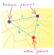
trilateration
URL copiedShare URL
[measurement, navigation]
Determining the position of a point on the earth's surface with respect to two other points by measuring the distances between all three points.