A to Z GIS | Explore this related guide, featuring updated terms and graphics and developed in coordination with Esri’s GIS Dictionary team.
Learn more about A to Z GIS
GIS Dictionary
Browse dictionary
TLM
URL copiedShare URL
[thematic mapping, geography]
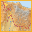
Acronym for topographic line map. A map that uses line contours to show elevations and depressions of the earth's surface. Topographic line maps may be used to portray topography, elevations, infrastructure, hydrography, and vegetation.