A to Z GIS | Explore this related guide, featuring updated terms and graphics and developed in coordination with Esri’s GIS Dictionary team.
Learn more about A to Z GIS
GIS Dictionary
The GIS Dictionary provides definitions for GIS terms related to operations such as analysis, GIS modeling and web-based GIS, cartography, and Esri software.
Browse dictionary
nadir
URL copiedShare URL
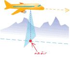
[photogrammetry,measurement]
In aerial photography and satellite imagery, the point on the ground vertically beneath the perspective center of the camera lens or scanner's detectors, or the point of convergence (vanishing point) for all vertical rays within a scene.
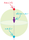
[aerospace]
In astronomy, the point on the celestial sphere directly beneath an observer. Both the nadir and zenith lie on the observer's meridian; the nadir lies 180 degrees from the zenith and is therefore unobservable.