A to Z GIS | Explore this related guide, featuring updated terms and graphics and developed in coordination with Esri’s GIS Dictionary team.
Learn more about A to Z GIS
GIS Dictionary
The GIS Dictionary provides definitions for GIS terms related to operations such as analysis, GIS modeling and web-based GIS, cartography, and Esri software.
Browse dictionary
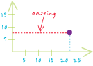
easting
URL copiedShare URL
[measurement,coordinate systems]
The distance east of the origin that a point in a Cartesian coordinate system lies, measured in that system's units.
[measurement,coordinate systems]
The x-coordinate distance measured east from the origin in a grid coordinate system.