A to Z GIS | Explore this related guide, featuring updated terms and graphics and developed in coordination with Esri’s GIS Dictionary team.
Learn more about A to Z GIS
GIS Dictionary
Browse dictionary
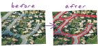
outline vectorization
URL copiedShare URL
[data conversion]
A vectorization method that generates lines along the borders of connected cells. It is typically used for vectorizing scanned land-use and vegetation maps.