A to Z GIS | Explore this related guide, featuring updated terms and graphics and developed in coordination with Esri’s GIS Dictionary team.
Learn more about A to Z GIS
GIS Dictionary
Browse dictionary
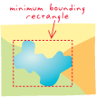
minimum bounding rectangle
URL copiedShare URL
[visualization techniques]
A rectangle, oriented to the x- and y-axes, that bounds a geographic feature or a geographic dataset. It is specified by two coordinate pairs: xmin, ymin and xmax, ymax.