A to Z GIS | Explore this related guide, featuring updated terms and graphics and developed in coordination with Esri’s GIS Dictionary team.
Learn more about A to Z GIS
GIS Dictionary
Browse dictionary
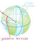
geodetic latitude
URL copiedShare URL
[geodesy]
Latitude on an ellipsoid; the angle between the horizontal equator line and a line perpendicular to the ellipsoidal surface at the parallel of interest.