A to Z GIS | Explore this related guide, featuring updated terms and graphics and developed in coordination with Esri’s GIS Dictionary team.
Learn more about A to Z GIS
GIS Dictionary
Browse dictionary
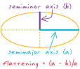
flattening
URL copiedShare URL
[geodesy, measurement]
A measure of how much an oblate spheroid differs from a sphere. The flattening equals the ratio of the semimajor axis (a) minus the semiminor axis (b) to the semimajor axis.