A to Z GIS | Explore this related guide, featuring updated terms and graphics and developed in coordination with Esri’s GIS Dictionary team.
Learn more about A to Z GIS
GIS Dictionary
Browse dictionary
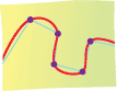
curve fitting
URL copiedShare URL
[spatial analysis]
The process of converting short connected straight lines into smooth curves to represent features such as rivers, shorelines, and contour lines. The curves that result pass through or close to the existing points.