A to Z GIS | Explore this related guide, featuring updated terms and graphics and developed in coordination with Esri’s GIS Dictionary team.
Learn more about A to Z GIS
GIS Dictionary
Browse dictionary
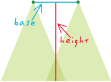
base height ratio
URL copiedShare URL
[remote sensing]
In aerial photography, the distance on the ground between the centers of overlapping photos, divided by sensor altitude. In a stereomodel, base height ratio is used to determine vertical exaggeration.