Bug
The search envelope is ignored when creating a new Spatial ETL tool in ArcGIS Pro.
| Bug ID Number | BUG-000144068 |
|---|---|
| Submitted | October 28, 2021 |
| Last Modified | June 5, 2024 |
| Applies to | ArcGIS Pro |
| Version found | 2.8 |
| Operating System | Windows OS |
| Operating System Version | 10.0 64 Bit |
| Status | Non-Reproducible |
Description
When authoring a workbench to create a new Spatial ETL tool, the WFS (Web Feature Service) reader in the FMW file can be configured to use the Search Envelope parameters to filter an area of interest in the input features. However, when running the Spatial ETL tool, the Search Envelope parameters are ignored and the entire WFS data is written.
Cause
This issue occurs when selecting a New ETL Workspace instead of an Existing ETL Workspace when creating the Spatial ETL tool.
Workaround
To resolve the issue, create the FMW file in the Workbench application in ArcGIS Data Interoperability and reference the FMW file when creating the Spatial ETL tool.
- Create the FMW file and configure the Search Envelope parameters for the WFS reader.
- Open ArcGIS Data Interop Workbench in the Windows Start menu.
Note:
For ArcGIS Pro 2.8 and below, the Workbench is launched by navigating to Analysis > Data Interop > Workbench. For more information, refer to ArcGIS Pro: A quick tour of the ArcGIS Data Interoperability extension for Desktop.
- In the Workbench window, click New. In the Create Workspace window, click Generate workspace > Choose.
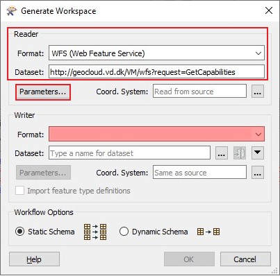
- In the Generate Workspace window, in the Reader section, for Format, select WFS (Web Feature Service).
- For Dataset, specify the WFS URL.
- Click Parameters.
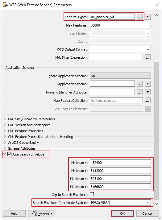
- In the WFS (Web Feature Service) Parameters window, in the Constraints section, specify Feature Types.
- Check the Use Search Envelope check box.
- Specify the Minimum X, Minimum Y, Maximum X and Maximum Y parameters.
- Specify the coordinate system in Search Envelope Coordinate System.
- Click OK.
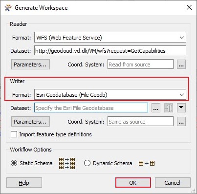
- In the Generate Workspace window, in the Writer section, for Format, select Esri Geodatabase (File Geodb).
- Click OK.
- In the Workbench window, click File > Save As.
- In the Save As window, save the FMW file in the ArcGIS Pro project folder.
- Create the Spatial ETL tool.
- Open the ArcGIS Pro project.
- Create a Spatial ETL tool referencing the FMW file created in Step 1. Refer to ArcGIS Pro: Reference an existing FMW file to an ETL toolbox for instructions.
- Run the Spatial ETL tool.
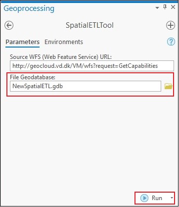
- In the Catalog pane, click Toolboxes > <ArcGIS Pro project name> > SpatialETLTool.
- In the SpatialETLTool window, specify a location for File Geodatabase.
- Click Run.
Steps to Reproduce
Bug ID: BUG-000144068
Software:
- ArcGIS Pro
Get notified when the status of a bug changes


Related Information
Discover more on this topic
Search for related information
Find training related to this topic
Explore ideas and give feedback
Get help from ArcGIS experts
Download the Esri Support App