HOW TO
Verwenden von Protokolldateien mit Geodaten von Videoflügen, die mit Scan Flight for ArcGIS erfasst wurden
Zusammenfassung
Note:
The Full Motion Video workflow in ArcGIS Pro requires the Image Analyst extension.
Video collected from a drone has great value. When a drone captures single frame images, tools such as ArcGIS Manager for Site Scan and ArcGIS Drone2Map can apply photogrammetric processing to create orthomosaics and other products that are accurately placed onto a map, but video presents a different challenge.
Site Scan Flight for ArcGIS can record GPS data, as well as camera orientation during a flight, stored in a CSV file referred to as the Geospatial Video Log (GVL) file. This log file can be used within ArcGIS applications to manage, view, and analyze the video on a map.
ArcGIS has two different environments for working with video and its corresponding GVL file:
-
If the video is aimed (primarily) toward the ground, the video footprint may be shown on the map using Full Motion Video (FMV) within ArcGIS Pro. This capability requires the Image Analyst Extension for ArcGIS Pro, and a post-flight process, known as multiplexing, must be applied using the Video Multiplexer geoprocessing tool. The Video Multiplexer embeds the flight telemetry from the GVL file recorded by Site Scan Flight into the video file. Refer below to FMV workflow in ArcGIS Pro. Note that the accuracy of the georeferenced video depends on the hardware available in the drone.
-
If the video is aimed (primarily) toward or above the horizon, the video footprint may not intersect the ground, but the camera location and orientation can be managed in ArcGIS using what is referred to as an Oriented Image Catalog (OIC). Refer below to Oriented Imagery workflow for video in ArcGIS section.
Vorgehensweise
To utilize the Video Multiplexer tool in ArcGIS Pro, two corresponding files are required:
- A video file
- A Geospatial Video Log file
- Ensure that the the newest version of Site Scan Flight for ArcGIS is installed.
- Open the app on the iPad.
- Complete any flight in video mode. This can be an autonomous flight, or a manual flight using Inspection mode. GVL files are automatically recorded.
- After the mission is complete, remove the SD card from the drone and copy the appropriate video files to a computer for post-flight processing.
- File names for videos are similar to the following: DJI_0038.mov.
- Export corresponding GVL files from the iPad.
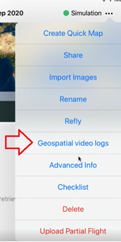
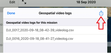
- A list of all GVL files may be accessed from the main settings in Site Scan Flight. GVL files from a specific mission can be accessed from the ellipsis icon drop-down in the Flights menu after selecting a flight. This calls up the listing of files. Use the share button in the upper right corner to copy the log files for transfer to another computer. Rather than a bulk export, there is the option to share (swipe left) or delete (swipe right) individual files.
- File names for GVL files include the video name and a unique date and time for the start of the video file, similar to the following: DJI_0038_YYYY-MM-DD_HH-MM-SS_videolog.csv.
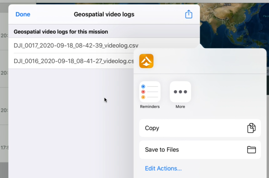
When sharing the GVL files, they are put into a zip archive file. When sharing a single GVL file after the flight, the name of the zip archive has the same name with .zip on the end. For example: DJI_0881_2020-09-30_01-28-41_videolog.csv.zip. When sharing multiple GVL files after the flight, the name of the zip archive has the timestamp of the time the files were shared, and the name has the pattern: SiteScanVideoLogs_{yyyy-MM-dd_HH-mm-ss}.zip. For example: SiteScanVideoLogs_2020-09-30_02-45-47.zip.
- Verify that there is one Geospatial Video Log file for each video.
- After confirming a successful copy of all videos and associated log files, the source files from the iPad and from the SD card may be safely deleted.
- This completes the workflow within Site Scan Flight. The next steps are to continue with the appropriate post-flight processing workflow.
FMV workflow in ArcGIS Pro
- Ensure that ArcGIS Pro version 2.4 or later is installed on the computer, and that the Image Analyst extension is licensed and enabled.
- Open ArcGIS Pro, and in the Catalog window, right-click Folders, and select Add Folder Connection.
- Navigate to the folder containing the files copied from Site Scan: the video file and its corresponding GVL file.
- Run the Video Multiplexer geoprocessing tool, and input the video file with its associated GVL file into the multiplexer.
- Create a new filename (with a full path) for the output video file. For example: inputfile_multiplexed.mp4 for a file in MP4 format, or a *.ts extension for files in Transport Stream format.
- Optional: To follow best practices for FMV, it is recommended to enter a DEM representing orthometric height, referenced to sea level, into the Video Multiplexer. This helps support future geospatial searches of multiple video files, but is not a required step.
- If a DEM for the project area stored as a local file is not available, use the World Terrain from the ArcGIS Online Living Atlas.
- Alternatively, a single value for the average ground elevation of the project area can be entered.
When the new video file is complete, it can be added into a 2D map or a 3D scene in ArcGIS Pro.
Note:
When viewing the file in ArcGIS Pro, if the video footprint does not appear to be the correct size, refer to the article: How To: Correct drone flight altitude data in Geospatial Video Log (GVL) files in Site Scan Flight for ArcGIS
The GVL file and FMV assume the drone is reporting flight altitudes as height above ellipsoid (HAE), but if the data is referenced to orthometric height (above sea level, ASL) or height above ground level (AGL), the height values may not be interpreted correctly by the Video Multiplexer.
Known limitations
As of ArcGIS Pro version 2.6, the FMV video player performance is not optimized for high-resolution 4K video. It is recommended to test different video resolutions to evaluate playback performance in ArcGIS Pro to decide the best resolution for data capture.
For more information about FMV in ArcGIS Pro, see the Related Information section below.
Oriented Imagery workflow for video in ArcGIS
Oriented Imagery is an alternative to FMV, for scenarios which includes either or both:
- Working with video aimed above the horizon
- Accessing video using a web app
Workflows for video as oriented imagery include one or both of two key components: publishing videos for viewing within an oriented imagery software client, and exploitation of the oriented video, which is dependent on the use case.
Workflows for video as oriented imagery are not included at this time. If this is needed, please contact cbenkelman@esri.com.
For more information about Oriented Imagery in ArcGIS Pro, see the following resources:
Artikel-ID:000024386
Hilfe von ArcGIS-Expert*innen erhalten
Die Esri Support-App herunterladen
Zugehörige Informationen
Weitere Informationen zu diesem Thema erkunden
Search for related information
Find training related to this topic
Explore ideas and give feedback