HOW TO
Konvertieren mehrerer KML-Layer in ein Shapefile
Zusammenfassung
KML is an XML-based file format for displaying information in a geographic context. While KML information can be drawn in many Earth-based browsers (including ArcGIS Earth and ArcGIS Pro), there are limitations when using them for GIS analysis.
This article describes the method to combine multiple KML layers into a single, usable shapefile to allow advanced GIS analysis on the features within.
Vorgehensweise
- Use the Batch tool to convert KML files.
- In ArcGIS Pro, navigate to Analysis > Tools.
- In the Geoprocessing pane, search for KML To Layer in the search box.
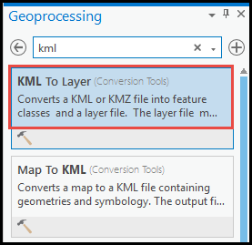
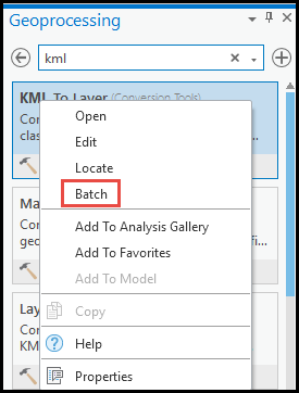
- Right-click the KML To Layer tool, and select Batch.
- In the Batch KML To Layer pane, under Choose a batch parameter, select the Make temporary batch tool option.
- Use the default details for Name and Location. Click Next.
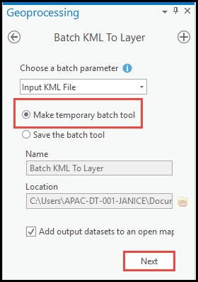
- Under Parameters, select all the KML layers for Batch Input KML File, and specify the location for Output Location. Click Run.

Note:
For the Batch Input KML File tool to work, do not remove %NAME% from Output Data Name.
- Use the Merge tool to combine the converted shapefiles.
- In ArcGIS Pro, navigate to Analysis > Tools.
- In the Geoprocessing pane, search for Merge in the search box. Select the tool.
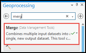
- In the Merge pane, under Parameters, select the shapefiles converted from the Batch Input KML File tool.
- Select the output location for Output Dataset. Click Run.
Note:
Ensure the selected layers contain the same geometry type (for example, merge all the polylines layers only).
Artikel-ID: 000026382
Holen Sie sich Unterstützung mit KI
Lösen Sie Ihr Problem schnell mit dem Esri Support AI Chatbot.


Zugehörige Informationen
Weitere Informationen zu diesem Thema erkunden
Search for related information
Find training related to this topic
Explore ideas and give feedback
Unterstützung durch ArcGIS-Experten anfordern
Beginnen Sie jetzt mit dem Chatten