Frequently asked question
What is the correct way to cite an ArcGIS Online basemap?
There are several ways to cite or attribute the ArcGIS Online basemaps that are used for publication, depending on the medium of publication. For each ArcGIS Online basemap, the proper attributions for the basemaps are as follows:
| Map | Attribution |
|---|---|
| World Imagery | Sources: Esri, DigitalGlobe, GeoEye, i-cubed, USDA FSA, USGS, AEX, Getmapping, Aerogrid, IGN, IGP, swisstopo, and the GIS User Community |
| World Street Map | Sources: Esri, DeLorme, HERE, USGS, Intermap, iPC, NRCAN, Esri Japan, METI, Esri China (Hong Kong), Esri (Thailand), MapmyIndia, Tomtom |
| World Topo Map | Sources: Esri, DeLorme, HERE, TomTom, Intermap, increment P Corp., GEBCO, USGS, FAO, NPS, NRCAN, GeoBase, IGN, Kadaster NL, Ordnance Survey, Esri Japan, METI, Esri China (Hong Kong), swisstopo, MapmyIndia, and the GIS User Community |
| National Geographic | Sources: National Geographic, Esri, DeLorme, HERE, UNEP-WCMC, USGS, NASA, ESA, METI, NRCAN, GEBCO, NOAA, iPC |
| Light Gray Canvas Map | Sources: Esri, DeLorme, HERE, MapmyIndia |
| USA Topo Maps | Copyright: © 2014 National Geographic Society, i-cubed |
| Ocean Basemap | Sources: Esri, GEBCO, NOAA, National Geographic, DeLorme, HERE, Geonames.org, and other contributors |
To use Bing Maps as the basemap, users must adhere to Microsoft Print Rights. The logo must not be altered, and copyright notices must be included on the map.
The following are the correct ways to cite an ArcGIS Online basemap used for publication.
- ArcGIS Online basemaps used in other publications
Author. “Map title” [format]. Scale. “Title of the complete document or site”. Information date. URL – this must include the full path of the document address, not just the home page of the web site (The date viewed).
Here is an example of referencing the ArcGIS Online World Topographic Map basemap using the style mentioned above:
Esri. "Topographic" [basemap]. Scale Not Given. "World Topographic Map". February 19, 2012. https://www.arcgis.com/home/item.html?id=30e5fe3149c34df1ba922e6f5bbf808f. (May 25, 2017).
- ArcGIS Online basemaps used on ArcGIS Online content
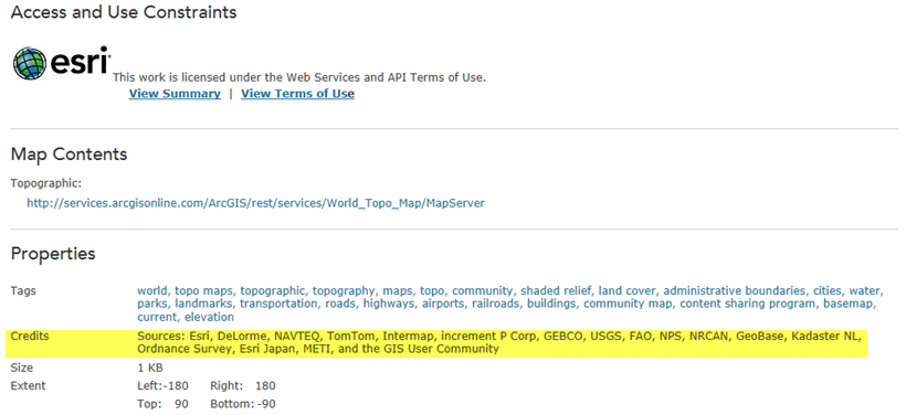
Figure 1: Example of the Credits field
- ArcGIS Online basemaps used in printed material
- ArcGIS Online basemaps used at public exhibitions
In some instances, users place all attributions in an exhibit on a single ‘credit panel’ at the end of each gallery or exhibition, instead of placing attributions on each map used. As long as this credit panel is located near the maps being used, there is no need to individually attribute each map. Nevertheless, to properly cite a publication, the copyright attribution must be on or near the map or image being used.
Article ID: 000012040
- ArcGIS Online
Get support with AI
Resolve your issue quickly with the Esri Support AI Chatbot.


Related Information
Discover more on this topic
Search for related information
Find training related to this topic
Explore ideas and give feedback
Get help from ArcGIS experts
Start chatting now