HOW TO
Extract polygon areas and calculate census data using data enrichment in ArcGIS Online
Summary
When working with census data, polygon boundaries may need to be split into smaller, more manageable areas for suitable data analysis. In ArcMap, the Spatial Overlay tool can be used; however, the Spatial Overlay tool is only available with the Business Analyst extension.
If the Business Analyst extension is not installed, the same results can be achieved by using ArcMap to create the desired polygons and enriching the data in ArcGIS Online. For example, if a set of polygons that overlap a census tract must be enriched within the area of a particular census tract where the polygons cross, the enrichment area is a subset of the census tract, but only within the boundaries of the tract. The enriched polygons must not fall outside of the boundaries of the tract, but do not use the complete boundary of the tract.
Procedure
The instructions provided describe how to extract polygon areas and calculate census data using data enrichment in ArcGIS Online.
- In ArcMap or ArcGIS Pro, add the polygons to be altered and the census boundaries to the map. If needed, create a subset of the polygons from the larger data. For more information, refer to ArcGIS Desktop Help: ArcMap - Selecting and Extracting data.
- Use the Clip tool from the Geoprocessing menu (from ArcToolbox, navigate to Analysis > Extract > Clip).
- In the Clip dialog box, set the Input Features (polygons to be altered) and Clip Features (census boundaries).
- Set the location and name for the Output Feature Class, and click OK to run the tool.
- Publish the clipped features as a hosted feature service to ArcGIS Online.
- In ArcGIS Online, navigate to My Content and add the feature layer to the map viewer. To do so, click the drop-down arrow next to the layer name, and select Add layer to new map.
Warning:
The next step requires performing analysis and charges credits to the ArcGIS Online organizational account. It is recommended to first test only one or two features, to ensure the output received are the desired results. For more information, see Service Credits Overview.
- In the map viewer, click the Analysis icon
 below the layer name in the Contents pane.
 - Select Data Enrichment > Enrich Layer.
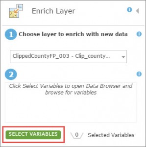
- Click Select Variables in the Enrich Layer pane, select the category (for example, Population) in the Data Browser, and select the variable(s) to add to the polygons.
- Click Apply when satisfied with the variable(s) selected.
- Click Run Analysis. The result of the enriched layer is added to the current map and as an item in My Content.
- Open the attribute table to view the new fields and values added to the polygons.
Article ID:000014773
- ArcGIS Online
Get help from ArcGIS experts
Download the Esri Support App
Related Information
Discover more on this topic
Search for related information
Find training related to this topic
Explore ideas and give feedback