Frequently asked question
What is the Parcel Fabric Geoprocessing toolset?
Answer
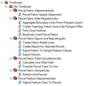
The Parcel Fabric Geoprocessing toolset, available for download here, is a replacement of the Parcel Fabric Data Migration and Analysis toolset. The updated version of the toolset consists of toolboxes containing Python script tools designed to carry out various tasks when managing parcel fabrics. The tools allow users working with parcel fabrics to perform data migration, feature and parcel fabric adjustment, field calculations, as well as exporting and reporting on parcels. The toolset also includes parcel fabric samples for Python developers.
The Parcel Fabric Geoprocessing toolset is supported from ArcGIS Desktop 10.4 onwards, with most of the tools also available for use in ArcGIS Desktop 10.3. To install the Parcel Fabric Geoprocessing toolset, watch the following video demo, Parcel Fabric Geoprocessing Tools Installation.
When downloaded, the toolboxes available in the Parcel Fabric Geoprocessing toolset can be located under Toolboxes > My Toolboxes in the Catalog pane in ArcMap. The Python script tools included in each toolbox are shown below.
Note:
If using an older version of the Parcel Fabric Geoprocessing toolset, download the most recent copy of the toolset. The last modified date of the toolset is stated on the download page.
Article ID:000013054
- ArcMap
Get help from ArcGIS experts
Download the Esri Support App
Related Information
Discover more on this topic
Search for related information
Find training related to this topic
Explore ideas and give feedback