PROBLEM
The Calculate Geometry tool produces incorrect results for basemaps
Description
When using the Calculate Geometry tool to perform calculations on basemaps, inaccurate results are returned.
Cause
Online basemaps use the 'Web Mercator' projection, but the 'Mercator' projection is used for navigation. A straight line drawn on the map is the bearing to fly a plane or sail a boat from the starting point to the destination, however this severely distorts distance and area.
Solution or Workaround
The following are possible solutions to the issue.
Assign a more suitable projection to the ArcMap data frame
Refer to the following article, Select a suitable map projection or coordinate system, for more information. The article is linked to the Projections Table, which lists all supported map projections in ArcGIS for Desktop and their properties.
Apply the selected projection to the ArcMap data frame
- Navigate to View > Data Frame Properties > Coordinate System Tab > Projected Coordinate Systems.
- Locate the desired projection that produces the most accurate results.
- Click Apply and OK.
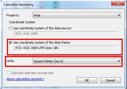
Get the accurate calculation output
- In the attribute table, navigate to Table Options, and select Add Field. Create a Double field, and assign a name with no spaces, and no more than 10 characters in length. For example, a name like Area_sqkm is suitable to store areas in square kilometers.
- Right-click the field header, and select Calculate Geometry.
- In the Calculate Geometry dialog box, select the option Use coordinate system of the data frame, and select the desired units as the requirement. The value calculated is shown in the attribute table.
Article ID: 000012117
- ArcMap
Get support with AI
Resolve your issue quickly with the Esri Support AI Chatbot.


Related Information
Discover more on this topic
Search for related information
Find training related to this topic
Explore ideas and give feedback
Get help from ArcGIS experts
Start chatting now