HOW TO
Add dynamic layer from a existing layer to the map using Java Connector API
Summary
There might be a need to add dynamic layer from an existing layer (a.k.a cloned layer) into the map object using ArcIMS Java Connector API. The thinking behind adding a dynamic layer would be to zoom to either set of features or to an envelope and change the rendering.
Comments within the code discuss:
-------------------------
- How to clone a layer from a existing layer (layer defined in the map configuration file)
- How to add spatial query to the new layer
- How to modify the rendering elements.
Note:
Dynamic layers will not work with ArcMapImage (MXD) service
Procedure
Code:

try {
    //Create new connection to the server
    //In this example we are using TCP Scheme
    ConnectionProxy cp = new ConnectionProxy();
    cp.setHost("imstest1");
    cp.setPort(5300);
    cp.setConnectionType("TCP");
    cp.setService("NorthAmerica");
    cp.setDisplayMessages(false);

    //Create a new map object for the above service
    Map map = new Map();
    map.initMap(cp,91,true,true,true,true);
    map.setHeight(500);
    map.setWidth(600);
    map.getLegend().setDisplay(false);
    map.setScaleSymbols(true);

    //Create new feature layer
    FeatureLayer flayer = new FeatureLayer("clonedlayer",null,null);
    flayer.setFeatureClass("polygon");
    flayer.setVisible(true);
    flayer.setName("mynewclone");

    //Set the datasource for the new layer
    Dataset ds = new Dataset();
    ds.setFromLayer("States");
    flayer.setDataset(ds);

    //Create a new filter and specify the spatial query
    String whereExp = "STATE_NAME='Nevada'";
    Filter filter = new Filter();
    filter.setWhereExpression(whereExp);
    filter.setGlobalEnvelope(true);

    //Set the filter on the new layer
    flayer.setFilterObject(filter);

    //Create new symbol
    SimplePolygonSymbol sps = new SimplePolygonSymbol();
    sps.setAntialiasing(true);
    sps.setBoundaryColor("0,0,0");
    sps.setBoundaryWidth(2);
    sps.setFillColor("255,255,0");
    sps.setFillTransparency(0.5);
    sps.setFillType("solid");

    //Add to renderer
    SimpleRenderer sr = new SimpleRenderer();
    sr.setSymbol(sps);

    //Create a label symbol
    TextSymbol ts = new TextSymbol();
    ts.setAntialiasing(true);
    ts.setFontSize(9);
    ts.setShadow("45,0,0");

    //Add to renderer
    SimpleLabelRenderer slr = new SimpleLabelRenderer();
    slr.setField("STATE_NAME");
    slr.setSymbol(ts);

    //Create Group renderer
    GroupRenderer gr = new GroupRenderer();

    //Add above two renderes to the group renderer
    gr.addRenderer(sr);
    gr.addRenderer(slr);

    //add group renderer to the new layer
    flayer.setRenderer(gr);

    //add the new layer to the map layer collection
    map.getLayers().add(flayer);

    // Add this line to send GET_IMAGE request rather than GET_FEATURE
    map.sendImageRequest();
    map.refresh();

    String mapURL = map.getMapOutput().getURL();
    System.out.println(mapURL);

} catch (Exception e) {
    System.out.println(e.getMessage());
}
Note:
Typically Filter object is associated with Map Object for sending a GET_FEATURE request. In this example we are interested in getting an image rather than features. Map.sendImageRequest() method indicates that we would like to send a GET_IMAGE request instead of a GET_FEATURE- Above code uses the following imports :
Code:

import com.esri.aims.mtier.io.ConnectionProxy;
import com.esri.aims.mtier.model.map.Map;
import com.esri.aims.mtier.model.map.layer.FeatureLayer;
import com.esri.aims.mtier.model.workspace.Dataset;
import com.esri.aims.mtier.model.map.layer.query.Filter;
import com.esri.aims.mtier.model.map.layer.renderer.symbol.*;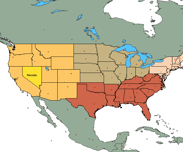
import com.esri.aims.mtier.model.map.layer.renderer.*; - Sample output generated. Note that the new layer is shown in yellow with the label.
Article ID:000008753
- Legacy Products
Get help from ArcGIS experts
Download the Esri Support App
Discover more on this topic
Search for related information
Find training related to this topic
Explore ideas and give feedback