Frequently asked question
How can I display ADF files from a coverage in ArcMap?
Answer
An ArcInfo coverage resides in an ArcInfo workspace. A workspace is a directory which contains two or more folders. One folder is named INFO and is described later in this article. The other folders are coverage folders that in turn contain files, most of which have the .adf extension. The names of these folders are the names of the coverages within the workspace.
Note:
The following are some limitations to coverage names:

• cannot be over 13 characters long
• cannot contain spaces
• cannot start with a number
• must be in all lower-case letters
• does not have an extension
The INFO folder contains files named arc.dir, log, and various other files named arcXXXX.dat and arcXXXX.nit. The DAT and NIT files are binary files. Each ADF file in a coverage folder 'belongs to', or is related to, a pair of these DAT and NIT files in the INFO folder.
The following is a sample view of the ArcInfo Workspace and contents, from Windows Explorer:
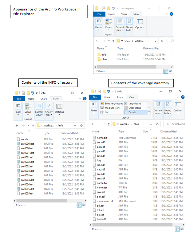
In the example, the ArcInfo Workspace is named 'sample' and contains one coverage named 'ohio83'.
The relationships between the ADF, DAT and NIT files are the reason why coverages cannot be copied with Windows Explorer. If a coverage folder, containing the ADF files, is copied or moved to another directory, using Windows utilities, the essential INFO files are left behind. The new coverage directory by itself is useless.
Coverages, however, can be copied using ArcCatalog. To add a coverage to ArcMap, click on the Add Data button and navigate to the workspace where the coverage is located. An icon for the coverage can be seen that consists of three boxes stacked together. The symbol on the coverage icon indicates whether the coverage has regions, polygons, routes, lines (arcs) or point features. Double-clicking on this icon opens the coverage, so all features that exist within the coverage can be seen, and allows the selection of the type of feature from the coverage to add to the map. The relevant features might be regions, polygons, routes, arcs, points, or annotations. Any of these feature types can be added to the ArcMap session.
Note:
The TIC feature class is part of the internal structure of the coverage, and usually is not a relevant feature for data display in ArcMap.
For more information about ArcInfo coverages, open the ArcGIS Desktop Help. Select the Index tab, and type in the word 'Coverages'. From the topics presented, particularly useful information can be found in the 'data model' and 'adding to maps' entries.
Article ID:000007209
- ArcMap
Get help from ArcGIS experts
Download the Esri Support App
Discover more on this topic
Search for related information
Find training related to this topic
Explore ideas and give feedback