PROBLEM
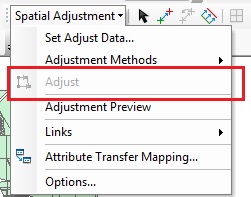
The Adjust option on the Spatial Adjustment toolbar is disabled
Description
The Spatial Adjustment toolbar allows data to be adjusted so that it aligns with other datasets. These tools are useful if, for example, a layer of feature points that represent schools appear in a different location from where the schools on a satellite photo are located. Rather than creating new feature points for those schools and resetting the attributes for every new point, the Spatial Adjustment toolbar can transform the feature points to the correct location.
Note:
Spatial adjustment must be performed in an editing session. To start an editing session, activate the Editor toolbar, and click the Start Editing option in the Editor drop-down menu.
In certain scenarios, despite being in an editing session, the Adjust option is disabled. This prevents the user from performing spatial adjustment.
Cause
A few criteria must be fulfilled before performing spatial adjustment. The following ArcGIS Help document describes this in detail: ArcMap: About spatial adjustment.
The following reasons are the main causes for the Adjust option to be disabled:
- The layer(s) to be adjusted have not been selected via the Set Adjust Data option.
- Displacement links have not been set for the data, or not enough displacement links have been set on the data.
Solution or Workaround
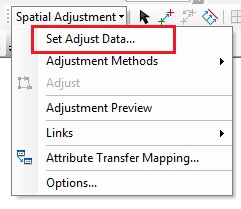
If the appropriate number of displacement links have already been created in a previous editing session, use the Set Adjust Data option, otherwise, use the latter option.A. Choose the input data for spatial adjustment
- If necessary, activate the Spatial Adjustment toolbar by navigating to Customize > Toolbars > Spatial Adjustment.
- Click the drop-down menu, and select Set Adjust Data.
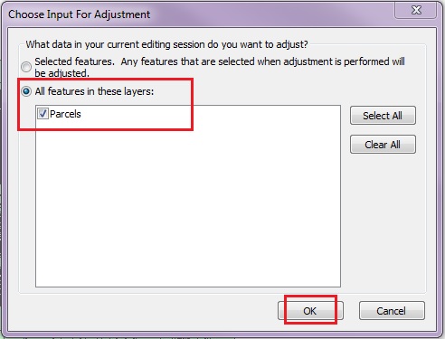
- In the Choose Input For Adjustment window, select the All features in these layers option, and select the layers to be adjusted.
Note:
Ensure the data are loaded to the map document before setting the data to be adjusted.
- Click OK.
B. Create a sufficient number of displacement links
Depending on the type of adjustment method being used, a minimum number of displacement links must be present in the data. For example, when performing an affine transformation, a minimum of three displacement links is required. These displacement links are required to show where the source and destination coordinates are for the adjustment.
Ensure the adjustment contains the required number of displacement links. If none exist, start an Edit session, use the New Displacement Link tool on the Spatial Adjustment toolbar, and set the locations for where the data must be realigned. For more information, refer to the following Help document: ArcMap: About spatial adjustment transformations.
For detailed instructions on creating displacement links, refer to the ArcGIS Help documents provided in the Related Information section below.
Article ID:000001117
- ArcMap
Get help from ArcGIS experts
Download the Esri Support App
Related Information
Discover more on this topic
Search for related information
Find training related to this topic
Explore ideas and give feedback