A to Z GIS | Explore this related guide, featuring updated terms and graphics and developed in coordination with Esri’s GIS Dictionary team.
Learn more about A to Z GIS
GIS Dictionary
Browse dictionary
smoothing
URL copiedShare URL
[visualization techniques]
In cartography, reducing or removing small variations in a line or other feature to improve its appearance or simplify the feature's representation.
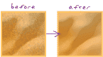
[image processing]
The process of reducing or removing small variations in an image to reveal the global pattern or trend, either through interpolation or by passing a filter over the image.