A to Z GIS | Explore this related guide, featuring updated terms and graphics and developed in coordination with Esri’s GIS Dictionary team.
Learn more about A to Z GIS
GIS Dictionary
Browse dictionary
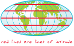
latitude
URL copiedShare URL
[geodesy, measurement]
The location of a point on the earth's surface, stated as an angular measurement in degrees, minutes, and seconds north or south of the equator. Lines of latitude are also referred to as parallels.