A to Z GIS | Explore this related guide, featuring updated terms and graphics and developed in coordination with Esri’s GIS Dictionary team.
Learn more about A to Z GIS
GIS Dictionary
Browse dictionary
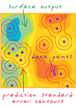
kriging
URL copiedShare URL
[statistics, spatial analysis]
A spatial interpolation technique used to estimate values at unmeasured locations based on known values at nearby locations. Known values are given weights based on the distance between the measured points, the prediction locations, the overall spatial arrangement among the measured points, and the correlation between data values given their distance apart. Kriging is unique among interpolation methods in that it provides a method for characterizing the variance, or precision, of the predictions. Kriging is based on regionalized variable theory, which assumes that spatial variation in the data being modeled is homogeneous across the surface (that is, the same pattern of variation can be observed at all locations on the surface). Kriging was named for the South African mining engineer Danie G. Krige (1919 – 2013).