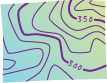
index contour line
-
[symbology]
On a topographic map, a contour line that is drawn with a thicker line symbol than the intermediate contour lines and usually labeled with the elevation that it represents. Depending on the contour interval, every fourth or fifth contour line may be an index contour.