A to Z GIS | Explore this related guide, featuring updated terms and graphics and developed in coordination with Esri’s GIS Dictionary team.
Learn more about A to Z GIS
GIS Dictionary
Browse dictionary
declination
URL copiedShare URL
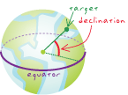
[measurement, coordinate systems]
In a spherical coordinate system, the angle between the equatorial plane and a line to a point somewhere on the sphere.
[geometry]
The arc between the equator and a point on a great circle perpendicular to the equator.
[aerospace]
The angular distance between a star or planet and the celestial equator.