A to Z GIS | Explore this related guide, featuring updated terms and graphics and developed in coordination with Esri’s GIS Dictionary team.
Learn more about A to Z GIS
GIS Dictionary
Browse dictionary
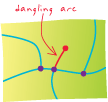
dangling arc
URL copiedShare URL
[geometry]
An arc with the same polygon on both its left and right sides and at least one node that does not connect to any other arc. A dangling arc often occurs where a polygon does not close properly, where arcs do not connect properly (an undershoot), or where an arc was digitized past its intersection with another arc (an overshoot). It is not always an error; for example, it can represent a cul-de-sac in a street network.